![]()
| Switzerland/France/Italy | Tour du Mont Blanc | 2000.07.05 - 07.09 |
Tour du Mont Blanc (TMB), Part 1
Updates based on our TMB hike in August 2001 are added in Orange.
Were it not for Elizabeth, the proprietor of the Bed and Breakfast we stayed at in Boat of Garten, Scotland (see Scotland), we wouldn't have known about this 11 day hike that loops around Mont Blanc and several other 4000+ meter peaks. Elizabeth showed us a book by Andrew Harper titled "Tour of Mont Blanc", published by Cicerone Press, that details a counter clockwise loop per the author's recommendation. Harper's book includes a description of the terrain, hiking distances and times, recommended stops, accommodation options, and various alternate hiking, bus, and train routes between stopovers that may appeal to the more rugged or less energetic. A perusal through the book was enough for both of us to decide to enjoy this lengthy hike when we reach the Alps. We easily found a copy of the book at a travel bookstore in London. From there we carried it through Paris and on to Switzerland in excited anticipation of our trek.
The book assumes the hiker is coming from Britain, and therefore recommends a starting point in France near Chamonix, the most convenient place to reach by car or train from London. In fact, most day's starting and stopping points on the circuit are accessible by train, bus, or cable car, and hikers can decide for themselves where to begin and whether they want to hike the full loop or only a portion of it. Since we came from Lucerne, Switzerland, we started the hike from Champex, listed as the starting point of day 8 out of 11 in the book.
Copying portions of the "Tour of Mont Blanc" is hardly adding value for future hikers of the circuit, and would infringe on copyrights. Instead, this page will assume that any serious hiker will buy the book - you'll want to carry the complete text in hardcopy if attempting the hike anyway. There are several aspects that Harper skips, maybe because his English audience would make similar assumptions as he. From our perspective, the TMB circuit is like hiking in luxury. The type of accommodation is extravagant by U.S. mountain hut standards. Food and drink is readily available at most lodges. Some even offer packed lunches for the next day's outing.
Another excellent TMB source is "Around Mont Blanc", a Rother Walking Guide ( http://www.rother.de ) by Hartmut Eberlein published in English. This Rother guide has color photos, detailed color topological hiking maps, and trail descriptions. It lacks accommodation information but presents practical hiking data better than Harper's book.
Travelers may want to lighten their load before starting the TMB circuit. We were fortunate to have friends in Lucerne who could keep one of our large backpacks for a month. On the Swiss side, most train stations offer luggage storage. The Chamonix SNCF train station offers luggage storage for FRF 20 per day per piece. There is no time limit. The storage room is on platform 1 of the station.
Several places on the TMB only accept cash (their own country's). Be sure to have Swiss Francs, French Francs, and Italian Lira in your wallet before starting. We recommend carrying the equivalent of US$200 in each currency. Chamonix has cash machines on the Plus and Cirrus networks, and there are also several money changers.
Each day on this web page is documented based on our direct experience of walking the loop. The specific accommodation information is added because Harper only provides lodge names, phone numbers, and the number of beds. Our intention is to help future hikers prepare their packing list and decide how much cash and food to carry. The accommodation we selected was mostly by chance, and may very well not be the best possible.
In addition to Harper's book, we needed a hiking map. Harper's book is good as long as his documented recommended or alternate routes are followed precisely. In reality, lodges fill up, especially on weekends, forcing a route alteration. Because a huge number of trails intersect with the TMB, and the TMB itself has several alternate paths, a detailed hiking map of the entire area is needed to make good decisions about what routes to take. The best hiking maps of the area are published by Institut Geographique National (IGN). Blue maps are 1:25,000 ratio and green maps are 1:100,000 ratio. The maps recommended by other French hikers are blue maps 3531 ET "St-Gervais" and 3630 OT "Chamonix". Between these 2 maps, the full set of hiking trails, roads, and cable cars around and including the TMB, with the exception of the very small section in Italy, are covered. These maps seem to be available at any town along the TMB. Late in the TMB, we found another map that covers the entire TMB. The map is by Didier Richard and titled "Pays du Mont Blanc, 8. Mont Blanc, Beaufortain, Aravis, Val d'Arly". The scale is 1:50,000. This Didier Richard map is available in Chamonix.
Another good source of information comes from other hikers on the circuit. On day 1, for instance, we learned from a French couple that one of the lodges at the opposite end of the circuit was destroyed by avalanche a few months ago. As a result, sleeping spaces are very limited at Rufuge Elisabetta they warned.
Some useful Tourist
Information Office numbers:
Chamonix Tourist Information 04-5053-0024 (Int'l +33-4-5053-0024)
Les Contamines Tourist Information 04-5047-0161 (Int'l +33-4-5047-0161)
Courmayeur Tourist Information 0165-842060 (Int'l +39-0165-842060)
Key used for lodging:
B = breakfast;
L = lunch;
D = dinner
V = Visa credit card accepted;
MC = Master Card credit card accepted
CHF = Swiss Franc; FRF = French Franc; ITL = Italian Lira
Day 1: Montreux (Switzerland) to Arpette (Switzerland)
We took public transportation from our overnight in Montreux to a point on the TMB called Champex. We then walked 30 minutes to Arpette for our first overnight stop.
Train from Montreux to Martigny: 26 minutes
Train from Martigny to Orsières: 27 minutes
Bus from Orsières to Champex: 25 minutes
Note: trains and buses to these remote villages are infrequent. Have the
information counter at any train station print out the best schedule for
you before departure.
The walk from Champex to Arpette was an easy, peaceful, and beautiful 30 minutes. We followed a crystal clear stream and had views of steep mountains all the way. The smells of the trees and flowers were delicious. We were happy we decided to hike the TMB after only a few minutes on the trail. TMB trail markers were either yellow painted arrows or diamonds, or white-red-white painted stripes. With the Harper book as our guide, the trail was easy to follow. The white-red-white marking is the standard TMB marker used in Switzerland (but not France or Italy).
|
|
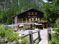
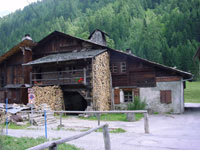
Lodge: Relais
d'Arpette Tel: 027-783-1221 Open: June 1 ~ October 15 Reservations required Room: CHF 70/pax incl D & B Dorm: CHF 52~57/pax incl D & B Packed L: add'l CHF 15/pax V/MC |
|
|
Day 1 was sunny and warm. The evening cooled down to pullover temperature. Mountains surrounded the lodge on all sides. Day 2 takes us up and over the mountains in the background. |
Day 2: Arpette (Switzerland) to Forclaz (Switzerland)
The hike from Arpette to Forclaz was a moderately strenuous 5.5 hours through some gorgeous country. It consisted no more than a climb up the far mountain seen in the photo of Day 1 and down the other side to the town of Forclaz. Mountains could be seen forward into France and backward to Switzerland from the highest point on the hike, a saddle called Fenêtre d'Arpette. The views were highly rewarding. The decent was a steep 2 hour walk adjacent to the Trient Glacier. As we moved from the top of the glacier to the bottom, the change in glacial zones from névé to icefall to ablation was apparent.
We met an older couple on the trail up to Fenêtre d'Arpette. The husband was 70 (we didn't get the wife's age). One of Wes' life goals is remain healthy enough to climb mountains at 70. They started hiking 5 years ago. At age 65 they found a new hobby - this couple was an inspiration.
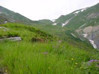
|
|
The steeply descending trail on day 2 followed the Trient Glacier. From half way down, we could hear the gushing of melted ice run under the icy surface. |
|
|
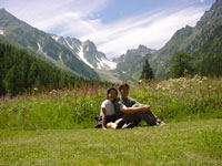
Beautiful views on either side of the Fenêtre d'Arpette urged us to stay for an hour and relax. The saddle elevation of 2665 M / 8743 ft and the steepness of the climb and decent forced many hikers to take regular breaks along the way. |
|
|
Lodge: Hôtel du
Col de la Forclaz Tel: 027-722-2688 Open: all year Room: CHF 132/double incl D & B Dorm: CHF 48/pax incl D & B Packed L: add'l CHF 10~20/pax V/MC |
Day 3: Forclaz (Switzerland) to Chamonix (France)
The night before, Wes started to get a sore throat. By the morning of day 3, there was no doubt that Wes was getting sick. Masami was fine except for some redness on her heals from rubbing on the inside of her boots. She put some moleskin on the sore areas and was ready to hike.
We had reservations in Argentière for the night of day 3 and in Chamonix for day 4. These we made in advance after discovering that lodges directly along the TMB were already fully booked for these Friday/Saturday evenings. We departed Forclaz cautious about Wes' energy level and headed for Argentière. Fortunately, the detailed hiking map 3630 OT showed us that we had 3 route options over the next saddle, Col de Balme, and a ski lift down the opposite side in case Wes couldn't make it by foot.
From Forclaz to Col de Balme, we chose the shortest route to the top. The hike descended 200 meters from Forclaz to the town of Trient, then climbed 950 meters to Col de Balme at 2191 M / 7188 ft. It was a fairly easy 2.5 hours to this point, but Wes was weak and Masami's sore heals turned to blisters. At Col de Balme, the boarder between Switzerland and France, we had our first look towards Mont Blanc, which unfortunately was covered by clouds. After eating lunch, we descended the quick and easy way - by ski lift and gondola to the town of Tour. Lift prices: FRF 72 round trip and FRF 51 one way per person.
At Tour, Masami suggested that we go directly to Chamonix. Wes thought a stop in Argentière was better since we already had reservations. Regardless, we both agreed that day 4 would be a rest day for Wes' cold and Masami's blisters.
The walk from Tour to Argentière was 30 minutes. In the middle of Argentière was a map listing various attractions and hotels. On the map we saw that our reserved beds were another 20 minutes south... We finally reached the lodge, looked inside, and turned right around bound for Chamonix. Fortunately, the proprietor was nowhere to be seen. The rooms were packed with 4-10 dilapidated beds each, the single toilet servicing the entire building (maybe 30 people?) was dirty and missing the seat, the main room seemed to double as a storage facility for dirty windows and miscellaneous rotting building supplies. To charge FRF 65 per person for this sty is robbery. In Argentière, we walked past many suitable hotels, but Harper's book only lists this dump. Why?
|
|
Lodge: Le Vieux Grassonette Open: July 1 ~ September 30 Bed: FRF 65/pax We recommend against this place. |
We exited Le Vieux Grassonette without being noticed, took a photo for our records, and looked for transportation to Chamonix. The bus stop was nearby, but the schedule said the next wouldn't arrive for another 2 hours. A minute later, the bus arrived 20 minutes behind schedule and seemingly just for us! Something was urging us to Chamonix this day. Had we not ridden the ski lift, we would have arrived to the Grassonette dump too late in the afternoon to find alternate accommodation. Had the bus from Grassonette to Chamonix not been late, we would have been stuck for several more hours. Had we not gone to Chamonix directly, we would have been caught in the rain the next day. Somebody or something is definitely watching out for us.
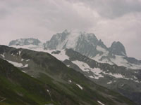
|
|
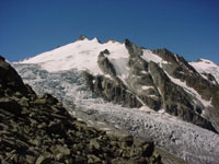
The Col de Balme (2191 M / 7188 ft) can be seen in the distance. The weather was overcast but warm. Only another hour to reach the Col from this point of our ascent. |
|
|
From Col de Balme, we had our first view of the 4000+ meter Alps Mountains. Unfortunately, Mont Blanc is hidden behind the clouds. Skiing here must be incredible. |
Day 4: Chamonix (France), rest day
This rest day couldn't have been timed better. It rained from morning to night. Tomorrow's forecast is sun with some clouds. Wes is less congested, but not healthy enough for a full day hike tomorrow.
Since Chamonix is a world famous ski resort town, we expected high rise hotels and unaffordable nightly rates. Surprisingly, we easily found rooms for Friday and Saturday nights for about FRF 300/room/night (about US$ 50). Site unseen, we ended up canceling our advance reservation in Chamonix that wanted FRF 65 per bed and an extra FRF 5 to use the shower. Although the reserved place in Chamonix couldn't have been worse than the Grassonette dump, there's value in paying a bit more for a private room to use consecutive nights.
At breakfast, we met a small team planning to climb Mont Blanc in the rain. At first glance, it looked like a French mountain guide leading a few fit young Americans. We wondered if they were serious about attempting this 4808 M / 15,774 ft peak in this miserable weather. After a few minutes of chatting, we found out these guys not only know what they're doing, they're serious mountaineers. American guide and founder of Sierra Mountaineering International (web: http://www.sierramountaineering.com), Kurt Wedberg was leading a group of American clients on a climbing tour through Europe. In France, he teamed up with French guide Yves Astier (web: http://perso.wanadoo.fr/yves.astier/) who's scaled 138 peaks in the Andes, Himalayas, and other mountain chains around the world. Yves' qualifications include climbing speed records in Chamonix up the Gervasutti du Tacul spire and the Arêtes de Peuterey. Kurt, making Bishop, California his home, has successfully reached the highest peaks in N. America (McKinley), S. America (Aconcagua), Africa (Kilimanjaro), and Asia (Everest). After Mont Blanc, he intends to hike the highest point in Europe, Mt. Elbrus on the Russian-Georgian border. He's an expert guide up McKinley and Rainier in the U.S. and leads expeditions to some of the highest peaks around the world.
|
|
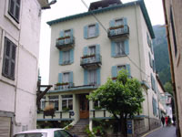
Our rest place
in Chamonix Lodge: Hôtel du Louvre Tel: 04-5053-0051 Open: all year Room: FRF 262~328/double B: add'l FRF 35/pax V/MC |
We found a fabulous
restaurant in Chamonix called Le Panier des 4 Saisons. Everything
served was excellent. The 4 course meal was FRF 110. Add drinks, and
you're probably looking at US$20 per person including the 15% service
charge. Make reservations if you want to eat here on Friday or Saturday
night.
Restaurant: Le Panier des 4 Saisons
Tel: 04-5053-9877
Dinner hours: 19:30 ~
Address: 24, galerie Blanc Neige rue Paccard
Day 5: Chamonix (France), another rest day
Wes is still congested and low on energy. The rain stopped, but the sky is overcast and views to the mountain peaks are blocked. Had the sky been clear, we would have ridden the gondola up to Aiguille du Midi, a rocky point at 3842 M / 12,605 ft from which Mont Blanc can be viewed. Gondola prices: FRF 200 round trip per person to Midi, FRF 300 round trip per person to Helbronner, the peak further south at the French/Italian boarder. It's possible to purchase a one way ticket for slightly less to Helbronner and descend on the Italian side to Courmayeur. To do this, you'd need to carry Italian Lira and purchase the Italian half of the travel at Helbronner.
Today is another rest day.
Copyright © 2000-2002 Wes and Masami Heiser. All rights reserved.