![]()
| Nepal | Annapurna Circuit | 2001.10.22 - 11.11 |
Annapurna Circuit
The Annapurna Circuit is a 15-18 day loop around the Annapurna mountains in central Nepal. Reputed to be one of the prettiest trekking areas readily accessible to tourists, this route is popular and attracts up to 67,000 hikers per year. The ideal trekking months are late-March to mid-May and early-October to late-November. These months have the least precipitation and are warm enough to cross the 5416 meter (17,770 foot) pass without crampons.
Between the awesome scenery, diversity of terrain, and inexpensive lodging and meals, hiking in Nepal may be the best value-for-money hiking in the world. Trekking enthusiasts will love the Annapurna Circuit.
An Annapurna Conservation
Area Project (ACAP) permit is required to enter the Annapurna Conservation
Area (ACA). Both the Annapurna Circuit and Annapurna Sanctuary treks enter
the ACA. Purchase permits at the ACAP office in Kathmandu or Pokhara
(office hours 09:00-17:00 Sunday-Friday) for 2000 NPR or at the APA
entry points for 4000 NPR.
The Pokhara ACA Office informs: "The Annapurna
Conservation Area Entry Permit (EP) Counter of Lakeside will be shifting to
a new location at Pardi Damside, situated at the tail of Fewa Lake.
The Counter will be located inside the Nepal Tourism Board's (NTB) Tourist
Service Center building. We will start our service from this new location
from 1 September 2004."
Regular ACAP office and police checkpoints verify that all hikers have a permit.
Insurance: Hiking at high elevation far from public transport access has inherent dangers. Carry insurance that includes helicopter rescue and evacuation in case of natural disaster or personal injury. Prior to departing on the trek, record your insurance information with your embassy in Kathmandu in case a rescue operation requires insurance money confirmation prior to launching the rescue. We heard of a case where an insured hiker in distress who didn't record his insurance information with his embassy had to prove that he had funds in his home country to cover the full cost of the rescue before a helicopter was dispatched.
Maps: Large 1:50,000 scale and tiny 1:200,000 scale topographical maps are easily found in Kathmandu and Pokhara. The 1:200,000 scale "Annapurna Conservation Area" pocket map (cost is 100 NPR, about US$1.35) was sufficient to complete the circuit on our own without a guide, though in off- season a guide is recommended.
Guides and porters are easily hired in Kathmandu, Pokhara, Besisahar, and many villages along the route. The cheapest option is to hire at the trailhead in Besisahar, but you get whomever is available. The most expensive place to hire is 2 or more days in. We met one trekking guide en route who we thought was superior to the rest in terms of communication, joint decision-making with his clients, and people-smarts. This guide is Arjun Neupane. He lives in Kathmandu and can be contracted for guide services across Nepal at email: arjunneupane@hotmail.com. Because we intended to build strength during the Annapurna Circuit for an ice climb up Lobuje East, we chose to hike without a porter.
Porter warning: Though many porters are good, some are a greater liability than assistance. We witnessed porters who were unprepared for the hike. They tend not to carry water nor appropriate shoes and clothing. The client is expected to provide sufficient shelter, clothing, and food in addition to porter salary. Keep this in mind when budgeting. Bring extra Chapstick. Many porters passing us en route had severely chapped and split lips. They asked to borrow our Chapstick but we had to refuse. Porter issues experienced by other hikers were price-increase demands a few days into the hike when the full wage is paid upfront and demands to stay at such and such accommodation against the client's wishes. Like tourists, porters are prone to altitude sickness at higher elevations. Anyone who becomes sick must be accompanied down as quickly as possible. A sick porter can severely impact your hiking schedule but it's better than losing a life.
Lodging: Most towns along the Annapurna Ciruit have hotels. Independent of hotel quality and facilities, accommodation prices are fixed by the ACAP. Some form of accommodation is found every 1~2 hours on the trail. Hotels don't have blankets, bath towels, or toilet paper. Bring a warm sleeping bag.
Camping: On the Annapurna Circuit, Annapurna Sanctuary Trek, and Tilicho Lake Trek, camping is possible but saves no money and adds weight. Camping equipment is needed, however, if crossing Tilicho Lake from Manang to Jomsom, hiking the high route past Dhaulagiri Base Camp from Beni to Marpha, or hiking the Larkya La Pass east of Bagarchhapp. Each of these treks are extremely strenuous and usually attempted only with guide and porters.
Food: Delicious inexpensive food is found in every town. There's no need to carry your own. Prices increase as the distance from the nearest road increases. Expect to pay about 100 NPR (about US$1.35) per person per meal at a distance of 1-day walk into the Annapurna Ciruit. 8 days in, expect a full meal to cost 500 NPR (about US$6.75). These prices are incredibly reasonable considering that everything is carried in by porters.
Water: Because plastic water bottles are not recycled in Nepal, the ACAP requests that all hikers to purify tap water or river water using a water filter or iodine tablets. Hotels sell one liter of boiled water for as little as 10 NPR 1 day into the Circuit and as much as 120 NPR 8 days into the Circuit. Along the route are infrequent "safe water" dispensaries that sell 1 liter for 35 NPR. The final option is to buy bottled water along the way against ACAP's request.
Money: Hotels and restaurants on the Annapurna Circuit only accept Nepali Rupees. Budget an average of 750 NPR (about US$10) per person per day for food and accommodation. Carry lots of small bills because often finding change is difficult. We did well carrying a stack of eighty 500 Rupee bills and a wad of miscellaneous smaller denominations.
Transportation to the Annapurna Circuit: Tourist buses depart once per day in the morning from Kathmandu (07:00 departure) and Pokhara to Dumre. From Dumre, tourist buses and local buses depart regularly for Besisahar, the town at the Annapurna Circuit trailhead. During peak months, reserve buses from Kathmandu and Pokhara at least one day in advance. There are several differences between a tourist bus and a local bus. Tourist bus: costs more, gives ticket priority to tourists, travels from one point to the next directly. Local bus: cheap, makes many stops, halts for up to 15 minutes at each police checkpoint, most passengers are locals and goats. From Dumre to Besisahar, the tourist bus costs 200 NPR and the local bus costs 40 NPR. We road cheaply with the goats.
KEY
SE = Starting
Elevation, FE
= Finishing Elevation
ME = Maximum Elevation Attained
HW = Hours Walked,
HR = Hours Rested,
HT = Hours Total
|
October 22, 1st night in Besisahar |
Elevation 760 meters / 2493 feet
Reaching the tourist bus departure point in Kathmandu at 06:45 for buses to Pokhara, we were surprised to see a long line of 30 buses, each operated by a different company and all leaving at the same time for the same place. Kathmandu to Pokhara is 243km, but we disembarked early in Dumre after 173km. From Dumre, a local bus took us to Besisahar, the starting point of the Annapurna Circuit. Total travel time was 8 hours.
We reached Besisahar at 15:00 and were lured by a hotel tout to a nearby grubby place. In hindsight, we should have walked 2 hours from Besisahar to Khudi. In Khudi, we would have had better quality accommodation and a shorter walk the following day.
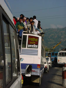 |
Driving from Kathmandu to Besisahar can be an interesting experience. Vehicles race through mountain roads with people crammed inside and riding on top. We rode a "tourist bus" from Kathmandu to Dumre. On our bus, the number of bus tickets were limited to the number of inside seats. |
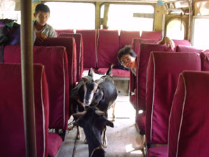 |
From Dumre, we rode a local bus to Besisahar. Masami rode alongside 3 goats on the 3-hour trip. All the non-foreign passengers were required to disembark at a police checkpoint at this point in our journey. |
|
October 23, Day 1: |
Besisahar to Khani Gaun |
|
1st Day on the Annapurna Circuit |
|
SE 760
meters / 2493 feet, FE
1100 meters / 3609 feet
ME 1310 meters / 4298 feet
HW 8 hours
+ HR 1 hour
= HT 9 hours
The main road through Besisahar continues to Khudi where the trail narrows to pedestrian traffic only. A continuous stream of tourists, porters, and mules lug supplies up and down the trail daily. Determining which fork to take is easily resolved by watching the flow of traffic, or in more remote areas, following the clumps of mule droppings. In high tourist season, there is no trouble finding accommodation and restaurant recommendations by talking to tourists looping the opposite direction and guides (hired by others) along the route.
Day 1 was a long but only moderately strenuous walk through rice fields and small villages. Most hikers stop in Bahundanda overnight as recommended by the Lonely Planet. We chose to continue another 90 minutes to find a quieter setting.
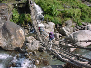 |
Masami crosses a bamboo suspension bridge over the Marsyangdi River. The surrounding landscape is lush and suitable for agriculture. |
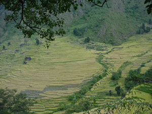 |
Every arable space is terraced for agriculture. Most of the land we crossed on our first day was planted with rice. |
|
October 24, Day 2: |
Khani Gaun to Tal |
|
2nd Day on the Annapurna Circuit |
|
SE 1100
meters / 3609 feet, FE
1700 meters / 5577 feet
ME 1700 meters / 5577 feet
HW 6.5 hours
+ HR 1.5 hours
= HT 8 hours
The trail to Tal passes 4 spectacular waterfalls and numerous small ones. The landscape changes from riverbed fields to rocky cliffs. Along the way, we see the first patch of green high on a precipice that hasn't been terraced for agriculture. Compared to yesterday, the hike was easier.
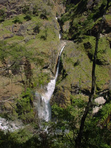 |
Thundering waterfalls thousands of meters high crash into the Marsyangdi River. |
|
October 25, Day 3: |
Tal to Koto Qupar |
|
3rd Day on the Annapurna Circuit |
|
SE 1700
meters / 5577 feet, FE
2600 meters / 8530 feet
ME 2600 meters / 8530 feet
HW 8 hours
+ HR 1 hour
= HT 9 hours
We intended to hike to the large town of Chame (elevation 2670 meters) but after 900 meters of ascent, our packs felt like they tripled in weight. We chose to stop early in Koto, 30 minutes walk before Chame. For the third full day, the trail stayed along the bank of the Marsyangdi River. Snow capped mountains gradually came into view.
|
October 26, Day 4: |
Koto Qupar to Humde |
|
4th Day on the Annapurna Circuit |
|
SE 2600
meters / 8530 feet, FE
3330 meters / 10,925 feet
ME 3400 meters / 11,155 feet
HW 8 hours
+ HR 2 hours
= HT 10 hours
Koto Qupar to Humde is a long day. At a lunch stop, we learned from 2 Germans, Ralph and Guenthar from Hamburg, that the highest lake in the world, Tilicho Lake, could be reached with a 3-day detour from the Circuit. Our interest piqued, we considered whether we had enough days in the ACA before our scheduled ice climb up Lobuje East. A quick count of remaining days, combined with the advice of a guide, revealed that a hike to the lake was possible. We re-planned our overnights accordingly.
Much of the trail to Humde crosses pine forest similar to those in the California Sierra Nevada Mountains. The similarity ends with a glance upward at the 6000~8000 meter peaks.
Few ascending hikers stop in Humde, the only airport on the east side of the Annapurna Circuit. Including us, only 5 guests stayed at our hotel. The other 3 were waiting for a flight out due to injury or altitude sickness. One was Mike, an American who seemed greatly relived to hear from us that everybody who hikes above 4000 meters gets altitude sickness sometime or other.
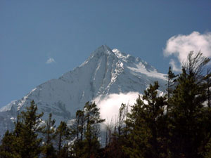 |
The 7939 meter high Annapurna II mountain is visible from the trail. The four highest peaks in the Annapurna Himalaya are numbered from one to four in order of decreasing elevation. The highest, Annapurna I, is 8091 meters (26,545 feet). |
|
October 27, Day 5: |
Humde to Khangsar |
|
5th Day on the Annapurna Circuit |
|
SE 3330
meters / 10,925 feet, FE
3734 meters / 12,251 feet
ME 3734 meters / 12,251 feet
HW 5 hours
+ HR 1.5 hours
= HT 6.5 hours
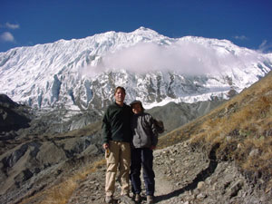
Humde to Manang is on the Annapurna Circuit. From Manang, we detoured to Khangsar, one of only two accommodation options between the Annapurna Circuit and Tilicho Lake at 4920 meters (16,142 feet).
Several of the Annapurna Mountains come into view along this stretch of the trail. From the town of Braga, 30 minutes before Manang, Annapurna II, Annapuran III and Annapurna IV peaks are visible. Braga is also a remarkably inviting town with rooftop terrace seating, freshly baked pastries, and Yak cheese. We ate our second breakfast here.
Finding the detour to Tilicho Lake from Manang is as easy as following the signs reading, "Tilicho Lake, ACAP". A slightly shorter route directly from Braga also exists, but it's safer to stop at the ACAP Information Office in Manang to find out if all trails are open. When we hiked, the lower trail from Braga and Manang to Khangsar was impassable due to a landslide.
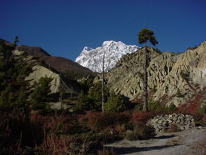 |
Further into the Annapurna Circuit, we see Annapurna III rising to 7555 meters. |
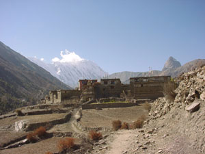 |
The village of Khangsar is a few hours off the Annapurna Circuit toward Tilicho Lake. Tilicho Lake is beyond the horizon behind Khangsar. It will take another 2 days to reach. |
|
October 28, Day 6: |
Khangsar to Tilicho Base Camp |
|
1st Day on the Tilicho Lake Route |
|
SE 3734
meters / 12,251 feet, FE
4150 meters / 13,615 feet
ME 4690 meters / 15,387 feet
HW 6 hours
+ HR 1 hour
= HT 7 hours
The only accommodation between Khangsar and Tilicho Lake at 4920 meters / 16,142 feet is Tilicho Base Camp (4150 meters / 13,615 feet) where one structure provides dormitory-style sleeping and food. A high route and low route connect Khangsar to Tilicho Base Camp. The low route undulates between 4000~4250 meters through 100 meter-high rocks jutting out of a steep scree slope. The high route climbs 5 hours to 4690 meters / 15,387 feet then suddenly descends through scree to Tilicho Base Camp. We chose the high route for several reasons:
The only disadvantage to the high route compared with the low route is 2 more hours of walking.
 |
One hour from Khangsar is a monastery. Masami drapped a white Tibetan scarf she carried from Lhasa over the Buddha and prayed that we both successfully reach Tilicho Lake and return safely. |
 |
Masami walks on the high route to Tilicho Base Camp. The prayer flags on the trail at 4690 meters mark the highest point for the day. Beyond the flags, a sharp and rather scary descent through loose gravel suddenly drop us to 4150 meters at the Tilicho Base Camp Hotel. |
|
October 29, Day 7: |
Roundtrip from Tilicho Base Camp to Khangsar |
|
2nd Day on the Tilicho Lake Route |
|
SE 4150
meters / 13,615 feet, FE
3734 meters / 12,251 feet
ME 5000 meters / 16,404 feet
HW 8 hours
+ HR 2.5 hours
= HT 10.5 hours
With breakfast ordered and packed the night before, we were up at 05:45 and on the trail at 06:15 to Tilicho Lake. 7000 meter mountains rose into view as we ascended to the 5000 meter high ledge overlooking an expansive azure Tilicho Lake. Claimed to be the highest lake in the world, we were surprised it wasn't frozen over.
After 30 minutes of gazing at the surrounding mountain peaks and watching ice bobbing along the lake surface, we descended to escape the cold harsh wind blowing over the pass. Climbing to 5000 meters took 3.5 hours but walking down to Base Cap was a quick 1.5 hours. After a filling lunch at Base Camp, we continued down to Khangsar on the low route.
 |
We stop for a rest at 4500 meters (14,764 feet) to give our bodies time to adjust to decreasing air pressure. Tilicho Peak in the background rises to 7134 meters. At the Tilicho Base Camp Hotel, we met a team hoping to summit Tilicho Peak in the coming 2 to 3 days. |
 |
At 5000 meters, a stupa with prayer flags mark the high point on the bank of Tilicho Lake. Behind rises Tilicho Peak. |
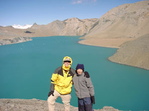 |
We made it! White specs in the lake are clumps of ice. At 5000 meters, the climate sustains zero vegetation. The landscape is sand, rock, water, and ice. The only living things are insane humans. |
|
October 30, Day 8: |
Khangsar to Lettar |
|
6th Day on the Annapurna Circuit |
|
SE 3734 meters / 12,251 feet, FE
4200 meters / 13,780 feet
ME 4200 meters / 13,780 feet
HW 4.5 hours
+ HR 1.5 hours
= HT 6 hours
Two routes connect Khangsar to the Annapurna Circuit. The low route drops to Manang (3540 meters / 11,614 feet). The high route climbs 300 meters above Khangsar, then drops to the Jharsang Khola River on the Annapurna Circuit at 4000 meters / 13, 123 feet. In addition to time savings on the high route, white-barked paper trees and colorful brush brighten the trail to make the hike more enjoyable than the wide, dusty, crowded Annapurna Circuit trail. Another 2 hours up the Annapurna Circuit brought us to Lettar where we stopped for the night.
|
October 31, Day 9: |
Lettar |
|
7th Day on the Annapurna Circuit, Rest Day |
|
Elevation 4200 meters / 13,780 feet
Masami woke with a sore throat and fever. We rested in bed for the day.
|
November 1, Day 10: |
Lettar to Thorung Phedi |
|
8th Day on the Annapurna Circuit |
|
SE 4200 meters / 13,780 feet, FE
4450 meters / 14,600 feet
ME 4555 meters / 14,944 feet
HW 2.5 hours
+ HR 0 hours
= HT 2.5 hours
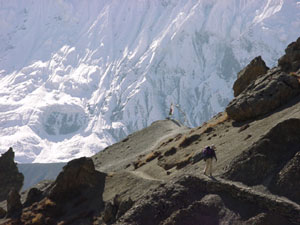
Masami felt better than the day before but her energy level was still low. We had the option to walk to Thorung Phedi at the base of the Thorung La Pass or continue to Thorung High Camp at 4800 meters / 15, 748 feet. A windy 2½ hour walk to Thorung Phedi brought us to a comfortable hotel with solar heated dining room and rooms with en suite toilets. Masami decided on the spot that we were finished hiking for the day.
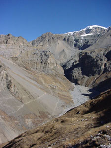 |
We approach Thorung Phedi, the small spec of buildings just left of the riverbed. From here, the trail goes only one direction: up across the Thorung La Pass. |
|
November 2, Day 11: |
Thorung Phedi to Jharkot |
|
9th Day on the Annapurna Circuit |
|
SE 4450 meters /
15,600 feet, FE
3550 meters / 11,647 feet
ME 5416 meters / 17,770 feet
HW 7 hours
+ HR 2 hours
= HT 9 hours
"Phedi" means "at the foot of". Thorung Phedi is at the foot of the 5416 meter high Thorung La Pass. The pass must be crossed to continue the Annapurna Circuit.
Not feeling 100% the night before, Masami decided to hire a porter from Thorung Phedi to the top of the pass. We agreed to pay 1500 NPR, 500 NPR in advance and the remaining 1000 NPR at the pass. A hotel staff member was selected. Departure time was set at 05:00.
At 05:00, with bags packed and dressed for the cold, we entered the hotel restaurant to meet our porter. He was still serving breakfast to other guests, but at 05:15 we were on our way.
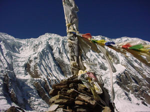
The first hour is a steep ascent from 4450 meters to 4800 meters where Thorung High Camp Hotel is located. We stepped inside for a quick pot of tea then continued the long ascent to the top. As we approached the pass, the wind increased in intensity. At the top it was fierce. In addition to the typical piles of rocks with attached Tibetan prayer flags, there was a stone teahouse. Dirty blankets in the corner were evidence that the young man selling tea actually slept there. Considering the high elevation and bitter cold, it was unbelievable that someone could survive.
Wes carried a white Tibetan scarf from Lhasa to tie to the steam of prayer flags at Thorung La Pass. With scarf tied and photos taken, we hurried down the opposite side to thicker air and warmer temperatures. The descent was 3 hours at a jog to reach the Muktinath, the first town at 3800 meters / 12,467 feet. In Muktinath, we ate a fabulous lunch at the Mona Lisa Hotel. After 30 more minutes downhill, we stayed overnight in the town of Jharkot.
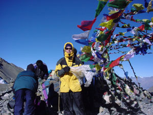 |
Wes holds his white Tibetan scarf now tied to the stream prayer flags at Thorung La Pass. The wind was cold and fierce at 09:00. It's said to blow stronger later in the day. |
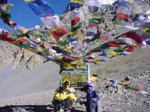 |
Wes and Masami pose at the sign congratulating hikers who reached the top of Thorung La. For all the effort, the scenery isn't very good. We much preferred Tilicho Lake. |
|
November 3, Day 12: |
Jharkot to Marpha |
|
10th Day on the Annapurna Circuit |
|
SE 3550 meters /
11,647 feet, FE
2670 meters / 8760 feet
ME 3550 meters / 11,647 feet
HW 6 hours
+ HR 1 hour
= HT 7 hours
Jharkot is a pleasant town with a monastery and large painted stupa. After breakfast we walked the town before strapping on our packs to begin a multiple-day descent to Pokhara.
The first 2 hours were gradual and peaceful. The trail paralleled a river where artificial caves dot the cliffs of the river walls. The caves were similar in appearance to those in Cappadocia, Turkey where persecuted Christians lived in secrecy. Locals, however, speculate that these caves were used for grain storage.
After 2 hours, the Annapurna Circuit turned south at a town called Kagbeni. Northward from Kagbeni to the Tibetan border is a restricted area. A maximum of 1000 tourists per year are issued a 10-day entry permit for US$700 plus US$70 for each day extension. We went south. From this point, we were forewarned about wind blowing northward, but nothing prepared us for the relentless gale forcefully blowing against us at 120km/h. Sand and pebbles from the riverbed and hillsides stung our face, got into the bandanna protecting our nose and mouth, and circumvented the sunglasses partially protecting our eyes. For 4 continuous hours we exhaustedly trudged into the wind. At times we were blown backwards a few steps or pushed to the left or right. Swirling sand gave some indication of the direction of the wind before each gust hit us. Still, it was difficult and miserable walking.
Wes wanted to reach Marpha, a town famous for apples and highly recommended by most guidebooks. When we arrived at 16:45, we discovered that everyone else on the Annapurna Circuit also decided to stay in Marpha. From north to south, we inquired at every hotel and guesthouse only to discover that the entire town was fully booked. 15 minutes south of the edge of town, we finally found a guesthouse with a vacancy.
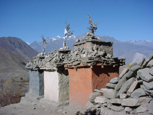 |
Small stupas, painted in the Tibetan colors black for protection, white for compassion, and red for wisdom, line the trail just south of Jharkot. |
|
November 4, Day 13: |
Marpha to Tukuche |
|
11th Day on the Annapurna Circuit |
|
SE 2670 meters /
8760 feet, FE 2590 meters /
8497 feet
ME 2670 meters / 8760 feet
HW 1 hour
+ HR 0 hours
= HT 1 hour
After a morning in Marpha visiting a Tibetan monastery, hiking up a hill behind the town, and getting Wes' hiking boots repaired, we walked a brief 1 hour 10 minutes down the Annapurna Circuit to Tukuche. The gale from yesterday resumed at 11:00 making today's short walk almost as miserable as the day before. A local told us that the forceful wind blows from 11:00 each day in the autumn from Kalopani in the south to the Tibetan plains.
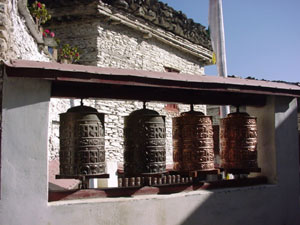 |
Prayer wheels line the entrance of the Marpha monastery. Marpha buildings are white in Tibetan style making the town attractive and popular with tourists. |
|
November 5, Day 14: |
Roundtrip from Tukuche to High Plains View Point |
|
Day hike from the Annapurna Circuit |
|
SE 2590 meters /
8497 feet, FE 2590 meters /
8497 feet
ME 3900 meters / 12,795 feet
HW 5 hours
+ HR 1 hour
= HT 6 hours
Two trails, one from Marpha and one from Tukuche, meet above the towns at 4100 meters. From there, they cross two 5000+ meter passes on the way to Dhaulagrili Base Camp. Part way up from Tukuche at 3800 meters is a sloped field where the yaks graze. We stayed in Tukuche for two nights at the High Plains Inn, the best accommodation to date on the Annapurna Circuit, and day-hiked past this pasture called the High Plains View Point.
The first hour through the apple orchards and corn fields is impossible to navigate without a hand-drawn map by the High Plains Inn owner Patrick. With map in hand, we began our walk. The first hour was a pleasurable stroll up a gentle slope through the trees, over a white wall, left past the water tap, through the corn fields, right at the thorn bushes, through the apple orchards, and over a stone wall. From there, the trail became obvious.
The higher we climbed, the steeper the incline became. The trail zigzagged through pine forest and up a red-rock cliff. White-bodied, black-faced monkeys scurrying above watched our approach and vanished by the time we reached their lookout. Further up, yaks descended with a stone-throwing, hollering man behind. This man seemed to have one of the most difficult jobs in the world. He'd convince the lead yaks to move a few meters downward as the others wandered up to munch on grass. He would race across a steep slope off the trail to throw rocks and holler at those that strayed, and while doing so, the lead yaks would wander back uphill. In ten minutes, the "yakherd" must have run several kilometers to push his herd of yaks down the mountain a mere 50 meters.
Our next source of entertainment were the clouds. The gusts of wind that blew sand in our faces and made hiking miserable the past two days now blew clouds at unbelievable speed over our view point at 3900 meters. To shield ourselves from the cold, we took refuge in a stone-walled roofless yakherd shelter. Directly overhead, cumulous clouds came into view and wisped by. The experience was surreal, comparable only to special effects cinema.
Before our descent, we bundled up to protect ourselves from the wind and ran down the mountain back to Tukuche.
That afternoon and evening was Tukuche's annual festival. Masked men danced in the monastery and village women performed an amateurish ill-prepared play. Most kindergarten productions are more professional. The townspeople, nonetheless seemed to enjoy themselves and that's what's important.
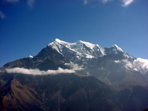 |
From our perch at High Plains View Point, we could look across the Kali Gandaki River valley at the 7000 meter high Nilgiri Mountains blocking the view of the Annapurna peaks. |
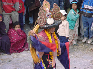 |
Men in costume danced in the courtyard of the Tukuche Monastery during the annual Tukuche festival. Dress was colorful, music was a combination of drum and cymbal, and dance movements were slow. |
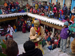 |
A masked man with cymbals descends the monastery stairs to the center courtyard while spinning in circles to the beat of the percussion band. Villagers from Tukuche and surrounding towns gather to watch the spectacle. |
|
November 6, Day 15: |
Tukuche to Ghasa |
|
12th Day on the Annapurna Circuit |
|
SE 2590 meters /
8497 feet, FE 2010 meters /
6594 feet
ME 2590 meters / 8497 feet
HW 5.5 hours
+ HR 1 hour
= HT 6.5 hours
To avoid the wind, we departed Tukuche at 08:00 to reach Kalopani by 11:00. Further wanting to avoid the hoards of people and mules on the Annapurna Circuit highway, we crossed the Kali Gandaki River and hiked in solitude along the opposite bank through grassy pastures and autumn leaves. It was the first enjoyable day on the Annapurna Circuit since Jharkot 3 days ago.
The route from Tukuche to Ghasa is a gradual descent. In terms of effort, it's an easy day.
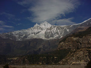 |
Mt. Dhaulagiri rises high above the clouds. This view is obscured by foothills along the Annapurna Circuit highway not from the opposite side of the Kali Gandaki riverbank. |
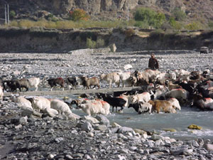 |
Goats cross the Yamkin Khola River, some over the narrow footbridge and others through the water. |
|
November 7, Day 16: |
Ghasa to Tatopani |
|
13th Day on the Annapurna Circuit |
|
SE 2010 meters /
6594 feet, FE
1190 meters / 3904 feet
ME 2010 meters / 6594 feet
HW 5 hours
+ HR 0 hours
= HT 5 hours
Although the 5-hour gradual descent from Ghasa to Tatopani should be an easy day, we found the hike to be exhausting. We were highly motivated hiking up to the Thorung La Pass but the descent feels like drudgery. We aren't sure if we're exhausted from 15 days of walking or simply de-motivated.
Tatopani has a hot spring, the main reason we and hundreds of other hikers choose to stay there. With hot spring in mind, we trudged on.
For the first time since starting the Annapurna Circuit, we passed more mules than people. This day, we were forced to stop multiple times to allow caravans of hundreds of mules to pass.
Tatopani is the converging point of all the friends we made over the past 2 weeks. Some had arrived days before and stayed put at the hot springs. Others reached Tatopani the same day as we, having explored other towns at a leisurely pace. Since Jomsom, we were separated from the others hiking across Thorung La Pass with us. Instead, we were surrounded by more overweight, less fit, cigarette smoking "hikers" and their porters doing a downhill walk from the Jomsom Airport to Pokhara. Upon reaching Tatopani, we were reunited with Brian and Adrian from Australia, Ilona from Holland, Annetta and Anya from Germany, and the Australian and Canadian couple, Steve and Heidi. We traded stories and had a marvelous evening.
Theft warning: Between Tatopani and Pokhara, there is a high incidence of petty theft. Sleep will all valuables in your sleeping bag. Thieves enter rooms at night while guests are sleeping, remove the bags, and steal the money. Don't assume the inside door latch will keep you secure.
|
November 8 & 9, Days 17 & 18: |
Tatopani |
|
14th & 15th Days on the Annapurna Circuit, Rest Days |
|
Elevation 1190 meters / 3904 feet
Masami's sore throat returned. Our bodies demanded rest. If resting for 2 days, Tatopani Hot Springs is one of the better places.
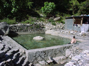 |
The hot spring at Tatopani is the closest to a Japanese rotenburo outside Japan we found on our travels to date. The water is clean, hot, and very relaxing. Not surprisingly, most Japanese who hike in the Annapurna region stop here. |
|
November 10, Day 19: |
Tatopani to Galeswor |
|
16th Day on the Annapurna Circuit |
|
SE 1190 meters /
3904 feet, FE
1170 meters / 3839 feet
ME 1190 meters / 3904 feet
HW 5.5 hours
+ HR 0.5 hours
= HT 6 hours
Two routes go south from Tatopani towards Pokhara. The easy route is 7 hours to Beni where regular buses depart for Pokhara on a 4-hour drive. The difficult route takes one day to climb 1560 meters to Ghorepani and one or two days down to Naya Pul where the Beni-Pokhara bus stops. Most people with time hike the difficult Ghorepani route to visit the nearby scenic Poon Hill (3193 meters / 10,476 feet) at sunrise. We chose to descend the easy way to give our bodies a chance to physically recuperate before our next big hike and ice climb. Advised that one town before Beni, Galeswor, is nicer than Beni, we chose to overnight in Galeswor and walk the final hour to Beni in the morning. Galeswor isn't very nice. Maybe Beni is worse.
The route from Tatopani to Galeswor stays along the Kali Gandaki River. Terraced fields line either bank.
|
November 11, Day 20: |
Galeswor to Pokhara |
|
17th Day on the Annapurna Circuit |
|
SE 1170 meters /
3839 feet, FE
820 meters / 2690 feet
ME 1170 meters / 3839 feet
HW 0 hours
+ HR 0 hours
= HT 0 hours
Jeep-taxis service the dirt road between Galeswor and Beni. For 30 NPR per person, the 1-hour walk to Beni is reduced to a 15-minute bumpy ride. From the jeep terminal, a 5-minute walk to the other side of Beni across a suspension bridge arrives at an open square where dilapidated buses and taxis to Pokhara await. Buses depart between 09:00~17:00 approximately hourly. Travel time to Pokhara is claimed to be 4 hours (took us 5) and costs 150 NPR per person. The bus ticket office is a small red brick building on the corner of the square.
Beni is a littered merchant town. Storefronts line the filthy dirt streets. Most likely, goods are purchased and ported to mountain villages from here. An Australian couple we met were happy with the accommodation at the north edge of town. We whizzed by in the window-less jeep-taxi and cannot comment.
Pokhara is about 80km away. The first 1½ hours the bus progresses slowly down rough dirt road and through streams. On the paved highway the bus speed increases, but engine maintenance every 10km delays our schedule. Two hours in the bus, yet still 60km from Pokhara, the bus stops for 30 minutes in a town. Maybe this is intended as a lunch stop. Five hours after departing Beni, the bus stops and all passengers disembark. We are still 5km north of Pokhara. Reluctantly, we pay a taxi 80 NPR to take us to the hotel district called Lakeside.
We give each other a congratulatory hug and kiss for completing the Annapurna Circuit. We're beat. Good night.
Copyright © 2000-2002 Wes and Masami Heiser. All rights reserved.