![]()
| Nepal | Everest Region | 2001.11.15 - 12.01 |
Lobuje East Expedition
Lobuje East (also spelled "Lobuche" on some maps) appears to have three peaks from afar. The highest peak is to the far left and reaches 6119 meters / 20,075 feet. The next highest is the False Peak on the right at 6069 meters / 19,911 feet. The middle "peak" is a large mound of ice on an outcrop of rock with a "knife edge" ridge and crevasses on either side. The standard climbing route is up the right side of the ice field to the False Peak, and when snow and ice conditions make it permissible, a technical crossing across the crevasses below the outcrop onto the true peak. Few people summit the true peak because of the difficulty, danger, and time requirement to cross from the False Peak.
We were interested in learning about mountaineering gear, its proper use, and safety. Nepal seemed to be the ideal place for an introduction for various reasons. Everyone speaks English, experienced mountaineers are common, gear is easily purchased or rented, prices are low, and the land has areas perfect for training and climbing. In the Thamel section of Kathmandu, we easily found two operators offering guides and gear to summit 6000+ meter trekking peaks. Both gave us optimistic sales pitches. "Sure you can make it. We take clients up all the time." We barely started asking questions before dismissing the operator Himalaya Glacier. They offered a climb to the top of Pisang Peak along the Annapurna Circuit. "We don't think its physically possible for anyone to ascent 3000 meters from the village of Pisang to Pisang Peak in 2 days," we interjected during their pitch. "Then you should go early to acclimatize on your own," they reasoned. Still, we knew from personal experience that even in our best condition, a rapid gain from 3000 meters to 6000 meters would be impossible for us. The second place, Equator Expeditions explained a more reasonable approach to the top of Lobuje East. Unfortunately, the guide leading the expedition was unavailable for questions. We couldn't be sure if client safety would be given top priority. Somewhat discouraged but still with hope and ambition, we went to Green Hill, the operator we used for our tour to Tibet. Maybe Green Hill can recommend someone, we thought. Sure enough, Green Hill pointed us to Far Out, a small group of experienced friends who will start operating in the spring of 2002. At Far Out we talked to Rajen Thapa, the man who leads mountaineering expeditions. After a thorough hour-long discussion, we felt completely comfortable. Check out Far Out on the web http://www.FarOutNepal.com.
With a group of four or more paying US$500 per person, Far Out offers two days of instruction and a three-day climb from Dzonglha (4830 meters) to Lobuje East. Included is the Trekking Peak permit, Sagarmatha National Park permit, mountaineering gear (tent, ice axe, crampons, gators, harness, carabinier, rope, snow bars, ice screws), 5-days of food, an instructor-guide (Rajen), an assistant guide, porters to carry the mountaineering gear, and cook. The client is responsible for clothing, sleeping bag, plastic boots, tips, and getting to and from Dzonglha. For a group of two clients, the fee increases to US$600 per person because of the pricing structure of the Trekking Peak permit.
Lobuje East is categorized by the Nepali government as a "Trekking Peak" but mountaineering gear is required to climb the mountain. Located above the town of Lobuje on the Everest Base Camp trail, the surrounding terrain has numerous trails that can help hikers acclimatize to high altitude prior to attempting the peak. The minimum time needed to summit and return from Lobuje East from Kathmandu is 12 days, assuming roundtrip flights between Kathmandu and Lukla and that the hiker is already fit and acclimatized for 5000 meters. To this 12 days, add 7 days in place of each of the Kathmandu-Lukla flights and an additional 3 or more altitude acclimatization days for those who haven't been above 4500 meters in the past week.
PERMITS
Trekking Peak permits cost US$350 for a group of 1~4 people plus US$40
for each additional person. For more information, contact the Nepal
Mountaineering Association, P.O. Box 1435, Kathmandu, NEPAL (Tel:
+977-1-434525, Fax: +977-1-434578, email:
office@nma.com.np,
web: http://www.nma.com.np).
In addition, a 1000 NPR per person Sagarmatha National Park permit must be purchased either in Kathmandu at the ACAP office in Thamel or on the trail just prior to park entry.
INSURANCE
Hiking at high
elevation far from public transport access has inherent dangers.
Carry insurance that includes helicopter rescue and evacuation in case
of natural disaster or personal injury. Prior to departing on the trek,
record your insurance information with your embassy in Kathmandu in case
a rescue operation requires insurance money confirmation prior to
launching the rescue.
MAPS
Large 1:50,000 scale
and tiny 1:60,000 scale topographical maps are easily found in
Kathmandu. The 1:60,000 scale "Everest Base Camp" pocket map (cost is
200 NPR, about US$2.70) was more than adequate.
GUIDES and PORTERS
Easily hired in Kathmandu, Lukla, and Namche Bazar. Remember, the client is expected to provide
sufficient shelter, clothing, and food in addition salary.
Keep this in mind when budgeting.
LODGING
Some form of
accommodation is found every 1~2 hours on the trail. Hotels don't have
blankets, bath towels, or toilet paper. Bring a warm sleeping bag.
CAMPING
For independent trekkers, camping is more of a hassle than staying in
lodges. Large organized groups always camp for logistical reasons. Hikes
above 5600 meters generally require camping equipment to stay overnight
at elevations higher than the highest towns for acclimatization purposes.
FOOD
Delicious
inexpensive food is found in every town. There's no need to carry your
own. Prices increase as the distance from Lukla increases.
Expect to pay about 250 NPR (about US$3.30) per person per meal at a
distance of 1-day walk in from Lukla. 5 days in, expect a
full meal to cost 500 NPR (about US$6.75). These prices are incredibly
reasonable considering that everything is carried in by porters.
WATER
Because plastic
water bottles are not recycled in Nepal,
hikers should purify tap water or river water using a water filter or iodine
tablets.
MONEY
Hotels and
restaurants in the Everest region only accept Nepali Rupees. Budget
an average of 1000 NPR (about US$13.30) per person per day for food and
accommodation.
TRANSPORTATION
Tourist buses depart Kathmandu for Jiri, the most common starting point
of the Everest Base Camp trek. The shorter and more expensive
alternative is to fly from Kathmandu to Lukla for US$91 one-way. Lukla
is 7-days walk in from Jiri, but only those who are already acclimatized
to higher elevations can consider this a 7-day time-saver.
TIPS
Tips are rarely expected. When we think tips are warranted because of
outstanding service, we split 10% of the overall operator fee between
the entire support staff. For this Lobuje East Expedition, we allocated
the equivalent of US$100 disproportionately according to rank between
our 7 support people as we explained to all what aspects of their
services we were most happy with. This small presentation was very well
received.
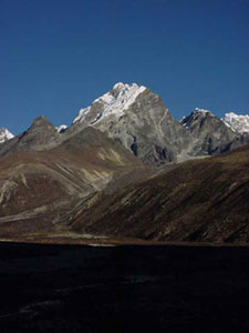 |
The ice-capped
peak of Lobuje East (6119 meters / 20,075 feet) photographed from the
4250 meter / 13,950 foot high Lobuje Khola River valley. We physically
trained for nearly 2 months before coming this far to attempt the
highest climb of our lives. KEY SE = Starting Elevation, FE = Finishing Elevation ME = Maximum Elevation Attained HW = Hours Walked, HR = Hours Rested, HT = Hours Total |
|
November 15, Day 1: |
Kathmandu to Phakding |
SE 1300
meters / 4265 feet, FE
2610 meters / 8563 feet
ME 2840 meters / 9318 feet
HW 3 hours
+ HR 0 hours
= HT 3 hours
Because of limited time between our Annapurna Circuit trek and the November 21 meeting time in Dzonglha to start our climbing instruction, we flew from Kathmandu to Lukla, a town 7-days walk in on the Everest Base Camp trek. The flight was scheduled to depart Kathmandu at 07:05. "When they say 07:00, it's 07:15. When they say 07:30, it's 08:00," the hotel manager at King's Land remarked. We should have listened to him. We reached the domestic terminal of the Kathmandu Airport at 06:30 and sat in the departure lobby until 08:00 when the fog began to dissipate. Just over one hour delayed, our 16-seater propeller plane lifted off.
The one-hour flight grazed the tops of lush 3000 meter foothills. Lukla, with its paved inclined runway, came into view. There are no second chances landing in Lukla. A vertical mountain face terminates the end of the runway. No landing mistakes, please! Our plane approached. We hit the runway hard. Alarms sounded and a red light illuminated in the cockpit. The terminating wall rushed toward us. "Please stop!" The pilots regained control and braked to a fast stop. Our hearts regained their beats as our tension released. Welcome to Lukla.
As we claimed our backpacks, a man approached. "Are you trekking?" "Why yes, and I believe everyone landing here plans to," Wes sarcastically rebuked. "Do you need a porter?" he asked next. "No, we already have one," we lied. Once outside the airport terminal, nobody bothered us.
In 10 short minutes we distanced ourselves from the commotion of the airport town. Lush forest of varying shades of green encompassed the well-worn trail. We were surrounded by 4000-meter foothills with occasional pointed snow-capped peaks looming above. The scenery was different than the Annapurna Circuit, and somehow more beautiful.
We immediately noticed a difference in the method of supply transport. Whereas mules are predominant in Annapurna, the Everest region uses zhom (female) and jobuke (male), a yak and cow mix, below 3500 meters and yaks above. Porters in Annapurna carry a simple straight walking stick. In Sagarmatha, they carry a thick T-shaped walking stick that doubles as a luggage rest.
Three hours downhill from Lukla, we stayed in Phakding for the night.
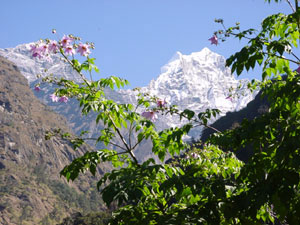 |
Lush green vegetation, pink flowers, and snow-capped mountains await trekkers disembarking their plane in Lukla. |
|
November 16, Day 2: |
Phakding to Namche Bazar |
SE 2610
meters / 8563 feet, FE
3420 meters / 11,220 feet
ME 3520 meters /
11,549 feet
HW 5.5 hours
+ HR 1 hour
= HT 6.5 hours
Phakding to Namche Bazar is a continuous 800 meter ascent. At the halfway point is the Sagarmatha National Park entrance, just above the town of Monjo. The security at the park entrance is serious. Two armed guards glare at trekkers. Behind the desk, an administrator checks permits and passports. Those arriving without permits can purchase them on the spot without surcharge for 1000 NPR. Paperwork is processed slowly. Expect a considerable wait.
The hike to Namche Bazar is nothing special. On the ascent, Masami ran out of energy. We shifted some weight by removing the plastic ice boots from her pack and strapping them onto Wes'. Wes ended up carrying both pairs of plastic boots until day 14. Exhausted from our walk, we gladly stopped for lunch at one of the wooden buildings serving lunch to porters and locals at the Namche Bazar town entrance. For 35 NPR each, a substantial meal of potatoes and bread was served. 45 minutes later, we departed rested and slightly more energetic to climb another 80 meters to Namche Bazar town center.
Namche Bazar is a significant settlement in an amphitheater-shaped mountain side. 200 vertical meters separate the lower buildings from the upper. In between are delicious bakeries, Tibetan jewelry stands, stores selling a huge range of hiking and mountaineering gear, a bank (no ATM), and even an Internet Café charging 25 NPR per minute for browser use and 60 NPR per minute for email. On Saturday morning, villagers from across the Khumbu and Ngozumpa Valleys gather for a huge outdoor market. We were fortunate to reach Namche Bazar on Friday night and have the chance to enjoy the market the next morning.
Most people stay in Namche Bazar for two days to acclimatize to the elevation, but since we were coming from the Annapurna Circuit, we could continue up the next day.
|
November 17, Day 3: |
Namche Bazar to Tengboche |
SE 3420
meters / 11,220 feet, FE
3860 meters / 12,664 feet
ME 3860 meters /
12,664 feet
HW 4.5 hours
+ HR 1.5 hours
= HT 6 hours
Since Masami lacked energy the day before, she would decide whether we rest in Namche Bazar for one day or continue walking. At breakfast, she felt well enough to continue. We departed at 09:20 intending to reach Tengboche. With a lunch stop at the halfway point, this proved to be an easy day.
Before leaving Namche Bazar, we wandered through the Saturday morning market. Hoping to find unique products carried by yak from Tibet, we were disappointed to find little more than fruit, vegetables, meat, and sub-quality clothing. 10 minutes at the market was plenty.
One hundred meters above Namche Bazar, trails continue up to Khumjung and right to Tengboche. One hour towards Tengboche, we came to the warm and sunny village of Kyangjuma with two hotels. One had a Tibetan-styled exterior. Inside, several monks chanted. We happened to visit on one of the five days per year that these monks perform a particular prayer ritual. Delighted with the atmosphere, we hoped to stay here on our return.
From Kyangjuma, the trail drops 400 meters to cross the Dudh Koshi River. Here we stopped for a flavorless lunch of fried noodles. Beyond the river, there are no facilities along the 2-hour 600-meter climb to Tengboche.
The accommodation in Tengboche is basic but staying overnight to visit the Tengboche Monastery and photograph it with Mt. Ama Dablam in the morning is rewarding. Masami bought a prayer scarf to place on the Buddha and asked that we both successfully summit Lobuje East and return safely.
|
November 18, Day 4: |
Tengboche to Dingboche |
SE 3860
meters / 12,664 feet, FE
4360 meters / 14,304 feet
ME 4360 meters / 14,304 feet
HW 4 hours
+ HR 2 hours
= HT 6 hours
Waking in Tengboche, the ground was covered with frost. Campers who hung laundry the night before woke to shirts and towels frozen solid. A clear blue sky and gorgeous snow-capped mountains made us forget about the cold as we walked around the town.
We departed Tengboche at 09:00. The first hour crossed beautiful forest with evergreens, paper trees, and varying brush canopying a meandering trail. The trail exits the forest at a river crossing and continues along exposed hillside with a perfect view of Ama Dablam. As the trail nears Dingboche, the top of Everest disappears behind the closer mountains. Clouds enshrouded the valley at 14:00. With the sun hidden, the temperature plummeted to 5°C. Stopping to rest meant a loss of warmth, so we continued slowly to conserve energy yet keep warm.
By the time we reached Dingboche, the clouds obscured all views. A quick towel-bath (body wipe-down with towel dunked in hot water) and hair wash prepared us for dinner and bed.
Dingboche is another popular acclimatization point.
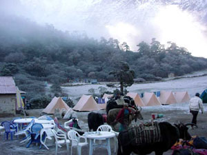 |
A large group of trekkers on an organized tour camp in the center of Tengboche town. Yaks are used to carry their supplies from camp to camp. |
|
November 19, Day 5: |
Dingboche to Chhukhung Ri |
SE 4360
meters / 14,304 feet, FE
4360 meters / 14,304 feet
ME 5550 meters / 18,209 feet
HW 7.5 hours
+ HR 2 hours
= HT 9.5 hours
The 5550 meter / 18,209 foot high Chhukhung Ri Peak is a long daytrip from Dingboche but it's an accessible point to help with altitude acclimatization. Masami didn't feel well enough to attempt the peak so Wes went alone.
The plan was to depart by 05:30, stop in Chhukhung for breakfast at 07:00, depart Chhukhung at 08:00, and reach summit by 11:00 before clouds obscure the mountains. Departure was on schedule. A layer of frost covered the ground and encrusted the vegetation. Streams were frozen. As the sun rose illuminating the highest mountain peaks, the sky turned pink. A Himalayan sunrise is truly mesmerizing.
Still on schedule, Wes reached Chhukhung at 07:00, but breakfast and Wes were separated by a partially frozen raging river. All the stepping stones were covered by a thick layer of ice. One slip could mean death. Walking 30 minutes upstream revealed no easy traverse. At 07:30, Wes gave up on breakfast and started climbing Chhukhung Ri Peak.
The first hour up was yak territory. Yak tracks crisscrossed scrub brush up a steep dirt hill to 5000 meters. Continuing higher, vegetation faded into a rocky landscape. At about 5250 meters, 900 meters above Dingboche, Wes started to feel the effects of altitude gain. The symptoms were shortness of breath, a mild headache, and tingling in the hands and arms. Since the summit was only 300 vertical meters higher, Wes pushed on.
Nobody else was at the summit. Wes had the entire view to himself. Everest was clearly visible to the East. All around were snow-capped mountain peaks. Below were azure lakes captured in glacial crevasses. Chhukhung Ri Peak is a beautiful hike.
The descent was easy. The 3-hour climb took one hour down to Chhukhung. By noon, the ice covering the stepping stones across the treacherous river by Chhukhung had melted. Crossing was possible. Wes tried to eat a simple lunch in Chhukhung, but the effects of the climb continued: headache and loss of appetite. On top of feeling sick, Wes was exhausted. Lunch was delivered to the table but Wes zonked out horizontally on the sitting cushions. The nap helped. After a leisurely partially eaten lunch, Wes could return to Dingboche.
All altitude symptoms vanished at the lower Dingboche elevation. Masami wasn't as fortunate. Instead of the hike to Chhukhung Ri Peak, she ascended a few hundred meters above Dingboche and was stricken by a severe headache. We only have two more days to acclimatize before our ice climbing instruction begins. Will we make it?
|
November 20, Day 6: |
Dingboche to Dughla |
SE 4360 meters /
14,304 feet, FE 4620 meters /
15,157 feet
ME 4830 meters / 15,846 feet
HW 3.5 hours
+ HR 0.5 hours
= HT 4 hours
The 2-hour walk from Dingboche to Dughla is a steady gradual incline along yak grazing pastures surrounded by 6000 and 7000-meter high ice-capped mountains. This scenic section high above the Lobuje Khola riverbed shouldn't be missed.
Because Masami suffered an altitude headache in Dingboche the day before, we chose to break our hike to Dzonglha into 2 days. Dughla is right in the middle, both in elevation and distance.
After checking into the Yak Hotel in Dughla, we continued up the trail to acclimatize. At 4800 meters is a memorial with stone monuments dedicated to those who perished on Mt. Everest. The most recent inscription was for a 22 year old who lost his life in 1999. Another monument was dedicated to Scott Fischer, the guide for the American Everest team during the May 1996 disaster and founder of Seattle based Mountain Madness. The entire memorial was eerie and moving at the same time.
We returned to Dughla with a clearer sense of the dangers of mountaineering.
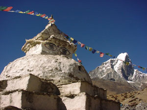 |
A stupa with prayer flags sits above the town of Dingboche. In the background rises the 6367 meter / 20,889 foot high Taboche Peak. |
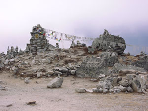 |
Stone monuments dedicated to climbers who lost their lives on Everest remind the living of the dangers of mountaineering. Numerous tombs are erected at 4800 meters at the base of the Khumbu Glacier that flows down from Mt. Everest. |
|
November 21, Day 7: |
Dughla to Dzonglha |
SE 4620
meters / 15,157 feet, FE
4830 meters / 15,846 feet
ME 4830 meters / 15,846 feet
HW 3 hours
+ HR 1 hour
= HT 4 hours
Several trails go toward Dzonglha. The map shows a low trail to Chola Tsho Lake, a high trail that passes by Dzonglha to Cho La Pass, and a middle trail that climbs to join the high trail. The actual middle trail gradually descends to meet the low trail. By the time we noticed the discrepancy, we were over 200 meters below the high trail. Improvising, we climbed through brush, scree, and rock to adjust our position. Masami, low on energy, was overcome with exhaustion. Wes felt energetic and carried Masami's pack in addition to his own. Feeling overly energetic with the anticipation of the upcoming climb, Wes raced along the trail carrying two packs. All came to a sudden halt when 20 minutes from Dzonglha Wes sprained his ankle. While resting, Masami caught up feeling recovered. We each carried our own packs the remainder of the way as Wes limped along tenderly. Fortunately, the ankle recovered over the next 2 days and posed no impediment to our Lobuje East climb.
After reaching the hotel in Dzonglha, Masami had an unusual symptom. She couldn't focus her eyes. For one hour, her eyesight deteriorated. Concerned that eyesight loss was due to the altitude, we consulted our climbing instructor who met us in Dzonglha. He suggested we wait another hour to assess Masami's condition. Thankfully, her eyesight returned to normal, and we didn't need to descend.
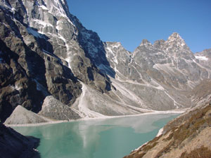 |
Azure-colored Chola Tsho Lake spans much of the distance between Dughla and Dzonglha. The Chola Glacier crackling down Taboche Peak continually drops chunks of ice into the lake. |
|
November 22, Day 8: |
Ice Climb Training |
SE 4830 meters /
15,846 feet, FE 4960 meters /
16,273 feet
ME 4960 meters / 16,273 feet
We joined our Lobuje East climbing team late afternoon the day before. This morning we started to get acquainted. There were three other clients, all from Brazil: Fernando, Kenji, and Helena. Fortunately, all three spoke English. Kenji and Helena, being third generation Japanese and having lived in Japan for 8 years, also spoke fluent Japanese. Communication within our group was no problem. We had two guides: Rajen and Javed, one cook: Siba, and four assistants who washed dishes, cooked, set up tents, and carried gear. Rajen, as one of the joint-owners of Far Our, contracted the others.
Our team of 12 (5 clients, Rajen, and 6 support members) departed Dzonglha after breakfast for a higher camp near rock and glacier needed for training. Camp consisted of excellent quality 4-season Terra Nova tents for clients, a rectangular dining tent, a large square kitchen tent, a small square toilet tent (with hole dug in the ground), and a 2-man Northface tent for the guides. The cook and assistants slept in the kitchen tent. After setting camp, we reviewed ice climbing gear and its proper use. Some of the gear was familiar to us but some was new. Click here for a gear review.
After a delicious lunch, the guides showed us 2-point and 3-point anchoring using one rope and carabiniers. Next we practiced abseiling down a fixed line using a harness and figure-of-8. At 14:30, the sun set behind one of the 6000 meter peaks and the temperature plummeted from 15°C to below freezing in minutes. We ran for more clothing and ended the training session.
That night dinner was served at 18:30, and we went to sleep at 20:00 with everything we didn't want to freeze tucked inside our sleeping bags.
|
November 23, Day 9: |
Ice Climb Training |
SE 4960 meters /
16,273 feet, FE 4960 meters /
16,273 feet
ME 5315 meters / 17,438 feet
Rajen's girlfriend, Pemba Doma, joined us in the morning intending to climb Lobuje East with us. As the first Nepali woman to summit Mt. Everest and live (One previous Nepali woman reached the top but didn't make it down.), her endurance and strength put us to shame. Lobuje East should be no trouble for her.
After an early breakfast, we left camp at 08:30 for the glacier at Cho La Pass. By 10:30, we were dressed in waterproof wear, holding ice axes, and stomping around in plastic boots and crampons. Our lesson started with the basics: angled steps for maximum grip on the ice, ice axe holding position, climbing up steep ice using the crampon's front-points, and securely planting the beak of the ice axe for climbing leverage. We climbed to the top of the glacier under Rajen's supervision, then roped up. Wes took the lead, tied with a follow-through figure-of-8 knot and 15 meters of rope slack straddled over his shoulder. Masami was second in line, 15 meters behind, tied in with a figure-of-8 knot. Behind Masami was Helena. Kenji brought up the rear. The basic lesson was walking without stepping on the rope while lengthening and reducing slack depending on the walking pace of the person immediately ahead. Next we simulated the fall of one member and practiced a group arrest using ice axes. Lastly we practiced crevasse rescue using a jet-pulley system pieced together with ice axe, sling, 2 jumers, and carabiniers. With three members pulling, the person in the crevasse could be lifted out. After rehearsing these basics, lunch was delivered from camp. Those wishing to could abseil down a vertical ice face just for fun.
By the time we returned to camp, the sun was hidden and temperatures were well below freezing. Bundled up, we dreamed about the beach and warmer climates.
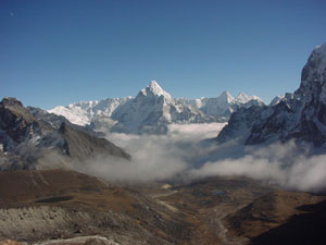 |
From Cho La Pass, we look down the Cho La Valley past Dzonglha at the 6856-meter high Ama Dablam. Every direction is beauty above the clouds. |
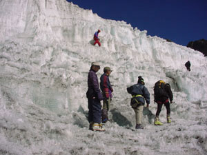 |
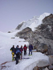
Fitted in plastic boots and crampons, we begin our ice training on Cho La Glacier on a perfectly warm and sunny day. Masami looks back as Rajen, Helena, and Kenji walk to the wall of ice. Above, Fernando and Pemba Doma prowl around. |
|
November 24, Day 10: |
Ice Climb Training |
SE 4960 meters /
16,273 feet, FE 4830 meters /
15,846 feet
ME 4960 meters / 16,273 feet
Day 10 training focused on ropes. After a quick review of figure-of-8, follow-through figure-of-8, clovich, Italian, and rip knots, we learned the Fisherman and 3 types of boreline knots: one to join 2 ropes of differing widths, one to tie around a harness, and one to use as an anchor. Our final instruction was the construction of a stretcher using a 50-meter length of rope, 2 sleeping mats, a sleeping bag, and a jacket. We practiced reconstructing the stretcher several times. Hopefully we won't need this skill on Lobuje East! After morning training, we returned to Dzonglha to rest for the afternoon in preparation for two days of hard climbing to the summit of Lobuje East.
That night, Helena decided against going to High Camp and Lobuje East summit because of knee pain.
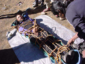 |
Fernando volunteers to be the patient as Javed teaches us how to construct an emergency stretcher out of common mountaineering gear. |
|
November 25, Day 11: |
Dzonglha to Lobuje East High Camp |
SE 4830 meters /
15,846 feet, FE 5300 meters /
17,388 feet
ME 5300 meters / 17,388 feet
HW 3 hours
+ HR 0.5 hours
= HT 3.5 hours
Perched on a wide granite ridge 2-hours climb below the snow and ice pack of Lobuje East, we set camp. From Dzonglha, we reached the location of this high camp in 3.5 hours at a slow walking pace. Times of ascent above 4000 meters are always regulated by the body's gradual adjustment to lower atmospheric pressure at higher elevation, not physical strength. In fact, the strong hikers who ascend too quickly are typically those who get sick and die from Acute Mountain Sickness (AMS). Elevations above 5000 meters are dangerous. At this altitude, the body's resistance diminishes. Skin abrasions and infections no longer heal, hemorrhages in the eyes, under the nails, and in the lungs are common, and a dry cough develops. On top of these common physical reactions, mountain sickness symptoms can develop making life miserable and forcing the trekker down to lower elevation.
The route from Dzonglha was pretty all the way. Between 4700~4900 meters, the air was perfumed with the sweet scent of juniper bushes covering the hillside. Below spanned the iced-over azure Chola Tsho Lake that we passed several days earlier from Dughla to Dzonglha. Past the juniper fields, we climbed a hill of boulders to reach Lobuje East High Camp (5300 meters). At High Camp, we could look down on Khumbu Glacier, look across to Ama Dablam, look back on Taboche Peak, and look up at Lobuje East.
Once again, Far Out provided luxury in the most remote of places. In addition to client tents, a kitchen tent and dining tent were erected. Food was plentiful and delicious.
Being higher up, the sun set later. Our camp was hidden in the shadows of surrounding mountains at 15:30 instead of 14:30. With the setting sun, the temperature suddenly plummeted from warm to freezing. Again, everything we didn't want to freeze got tucked into our sleeping bag. These items were camera, flashlight, and filled water bottles. Sleeping with these things night after night was uncomfortable but better than having them frozen and useless in the morning.
The dryness of climate is felt most in the fingers. The fingers swell from the altitude and the skin along the creases splits from the dryness. The splits aren't painful until lower elevation is reached and finger swelling reduces.
During a preparatory gear check, Pemba Doma showed us some custom Montura clothing she special ordered for her Everest climb. She'll be warm on this climb.
Tomorrow morning we plan to start climbing to Lobuje East summit at 02:30. Early to bed and early to rise.
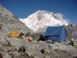 |
Far Out created a comfortable camp at Lobuje East High Camp (5300 meters / 17,388 feet). We were well equipped with new 4-season tents, warm water for washing, and a dining tent. Hot tea was delivered to each tent by the kitchen boys at wake-up time each morning. |
|
November 26, Day 12: |
High Camp to Lobuje East's False Peak |
SE 5300 meters /
17,388 feet, FE
5300 meters / 17,399 feet
ME 6069 meters / 19,911 feet
HW 10 hours
+ HR 2 hour
= HT 12 hours
Fernando had been hiking and camping continuously for the past 40 days, mostly at elevations above 4000 meters. He even climbed nearby Island Peak (6187 meters) less than two weeks before. But at Lobuje East High Camp (5300 meters), he succumbed to altitude sickness and had to be led down to Dzonglha. Altitude sickness is never predictable. Symptoms can be as mild as headache and nausea or as serious as coma and death. The only cure is to descend.
02:00 wake-up tea was delivered to our tent. Slightly warmed from the tea, we got out of our sleeping bags and had a simple breakfast in the dining tent. Departure was at 03:30, one hour behind schedule, on the dark moonless night. We were a group of 6: 3 clients, 2 guides, and Pemba Doma.
With headlamps strapped over our hats, we climbed 250 vertical meters of sloped loose stone in our plastic boots to the base of the ice. At one point, a false step by Javed sent a meter-long rock sliding down the slope, sparks flying from the friction as it raced past us. Fortunately, nobody was walking in its path. Treading more cautiously, we reached the ice line without further incident.
At the ice line, we clamped on our crampons, fitted our harnesses, and gripped our ice axes. The first patch of ice wasn't steep so we proceeded up to a ridge without rope. On the ridge, we divided into two groups of three. Javed led Wes and Masami on one rope, and Rajen led Kenji and Pemba Doma on another. Once roped, we began our climb as instructed during our training on Cho La Glacier: primarily, don't step on the rope with crampons. For about one hour, we ascended a 45° grade. With crampons and ice axe, we had little fear nor concern. But at 5600 meters, our breathing was hard, and we easily tired.
At 06:30, the sun rose shining light and warmth upon us. Concerned about the intensity of ultraviolet rays and their reflection off the ice, we stopped to put on sun block and cover our faces with a bandanna. Sun block out, we squeezed the tube but nothing came out. It was frozen. One of us should have had the sense to carry it under our layers of clothing. Javed was more prepared and gave us some of his.
We continued climbing slowly for another three hours. Most sections were at a 45° incline. One 200 meter section was steeper. We each concentrated on planting our crampons and ice axe firmly to prevent falling.
At 09:30, we reached the Lobuje East False Peak (6069 meters). We were separated from the actual peak (6119 meters) by a deep crevasse and a "knife edge"-narrow ridge. Rajen decided he wouldn't be taking us because of the technical difficulty to cross the ridge and the late hour we reached the False Peak summit. After 10 minutes of viewing the gorgeous scenery, Rajen urged us down.
The first 50 meters of descent were fine. Javed anchored his ice axe at the peak, locked on a carabinier, and belayed us one at a time using an Italian slip knot through the carabinier. When we each descended the length of our segment of rope, we anchored our ice axe, tied a clovich knot around the spade to anchor ourselves to the slope, and coiled slack rope that collected as the higher person descended. We repeated this process 3 or 4 times before Wes began to lose brain function. The first sign was that Wes couldn't tie a clovich knot. Nothing seemed familiar. The drape of the rope seemed odd. Trial and retrial to tie a clovich failed. Javed demonstrated from above, and following suit, Wes managed to tie a clovich knot. The same happened two more times. Wes grew more confused. A slight headache developed. Then, suddenly Wes couldn't control his bowels. Alert enough to tie himself to an anchored ice axe, he barely had time to loosen his harness and pull down his pants. It was a personal record for the highest poop. But this wasn't a laughing matter. Gradually, Wes lost control of his arms, then speech. He could sense that mental capacity to form thoughts was fading. Scared that he developed a mountain sickness called high-altitude cerebral edema (HACE), or swelling of the brain, he knew that he had to descend as quickly as possible. A few days later, we learned from a doctor in Pheriche that Wes didn't have HACE, but rather a temporary self-correcting stroke. Had it been HACE, the typical time from developing severe cerebral edema symptoms to death is under 24 hours. The only cure is to descend rapidly until symptoms disappear. Javed, seeing Wes' condition, yelled down to Rajen, "Wes is dying!" Wes could only blurt, "Get me a Diamox!" A Diamox and Advil swallowed with a gush of Gatorade, we hurried our descent. Wes' legs weren't coordinated and he kept slipping. "Aeeeb scared. Aeeeee.. tink... aeeee... hab... edeeema," Wes slurred to Rajen. "It's OK. Let's take you down," Rajen assured. From behind, Javed and Rajen held ropes around Wes' waist to prevent a long fall. The team continued to descend as quickly as possible, abandoning ice screw anchors and only relying on rope, crampons, and ice axe. At 5600 meters, Wes' condition started to improve. Clear speech returned and coherent thoughts were possible. At 5500 meters, Wes could walk without support. Finally, back at High Camp (5300 meters), everything was normal. The guides were still concerned and watched Wes' condition for the next hour. Any deterioration meant another descent to Dzonglha (4830 meters). All was OK, and we remained at High Camp for the night.
On the steep section of ice, Kenji also suffered typical mountain sickness symptoms: vomiting and headache. Even after returning to High Camp, his symptoms continued. His repeated vomiting wouldn't stop. He was taken down to Dzonglha that night.
Unpredictably, Masami was the healthiest client on the climb. She had a mild headache between 5800~6000 meters but nothing more severe. At High Camp, she was feeling perfectly well.
At 18:30, we collapsed in our tent from exhaustion and slept without dinner. What a day. Lobuje East is the most difficult mountain we've attempted. On Mt. Kilimanjaro, we cried with joy at reaching the summit. On Lobuje East, we cried from pain, fear, and misery.
Back at camp, Pemba Doma also said she would never return. "I felt less safe on Lobuje East than solo climbing to the summit of Everest," was her reason. Well if Lobuje East is harder than Everest, then we're just happy to be alive.
 |
On a level ridge at 5600 meters, the climbing team links together with rope before continuing the ascent up the ice on Lobuje East. Our route paralleled the rock line to the to nearest high point visible here. |
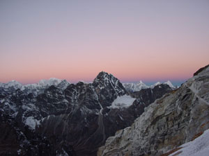 |
A colorful 06:30 sunrise over the Himalaya rewarded us for our efforts. |
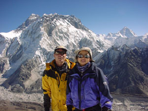 |
Wes and Masami stand atop the False Peak of Lobuje East. Far below is the Khumbu Glacier. A sliver of the top of Mt. Everest at the top left peaks over Mt. Nuptse. |
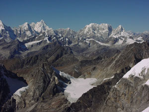 |
Far below Lobuje East is the 5330 meter high Cho La Pass with Cho La Glacier where Far Out trained us. |
|
November 27, Day 13: |
Lobuje East High Camp to Pheriche |
SE 5300 meters /
17,388 feet, FE
4240 meters / 13,911 feet
ME 5300 meters / 17,388 feet
HW 4.5 hours
+ HR 0.5 hours
= HT 5 hours
Happy Anniversary! This morning we celebrated our 8th year wedding anniversary at 5300 meters with a delicious breakfast prepared by the Far Out kitchen staff. As the only remaining clients on the mountain, we had a beautiful (but freezing cold) sunrise to ourselves.
Wes and Masami woke at 05:30 after a solid 11-hour sleep feeling perfectly healthy. Getting out of our sleeping bags and frost-coated tent in the -9°C dawn was the most difficult part of the day. Thereafter, we were rewarded with a hot breakfast and magnificent sunrise. Breakfast being the final part of the Far Out contract, we each went our separate ways from High Camp.
Once packed, we departed High Camp at 09:00 intending to reach Pheriche or Dingboche. But first we had to retrieve left luggage from the Himalayan View Guest House in Dzonglha. Coming from two nights at 5300 meters, the route to Dzonglha at 4800 meters felt highly oxygenated. Wes could jog the typical 2-hour hiking distance between the High Camp trail junction and Dzonglha in 50 minutes while Masami waited with the backpacks. With the retrieved luggage packed, we headed to Dughla for lunch. We asked the owner of the Yak Hotel in Dughla for a hotel recommendation in Pheriche that's as nice as the Snow Lion Lodge in Dingboche. "There aren't any but the nicest is the Pheriche Resort," he informed. "And the medical clinic in Pheriche has a free Acute Mountain Sickness (AMS) seminar daily at 15:00," he added. Wanting to ask a doctor about the altitude symptoms we experienced, we chose to head for Pheriche.
At the Pheriche Medical Clinic, we learned that we didn't know enough about mountain sickness. Some of the important points are so little known, even to experienced trekkers, that we decided to devote a separate web page to AMS. After the lecture Masami asked about her loss of visual focus in Dzonglha. Wes asked about his frightening condition while descending Lobuje East. The answer was the same in both cases. Dr. Ken Zafren stated that neither were direct AMS. "At high altitude, the body's natural resistances are reduced. Masami's vision problem could be the result of a brain anomaly that she normally compensates for. Wes' condition is caused by the absence of blood to a particular section of the brain, or in effect, a temporary and self-correcting stroke." He recommended that we both have a brain MRI and have a neurologist verify that our brains are normal before attempting another high altitude climb. Bummer. On our wedding anniversary, a doctor tells both of us to have our heads examined. "Most likely, there's nothing wrong. But if some anomaly is found now, then a corrective action could be taken early to prevent or reduce a potential adverse condition later in life," he reasoned. We think it's probably wise to follow Dr. Zafren's advice. What a dent in our travel budget that will be!
Later in Bangkok, we had our brains scanned. The neurologist jokingly confirmed that we have brains and cleared us for future high altitude climbs.
|
November 28, Day 14: |
Pheriche to Namche Bazar |
SE 4240 meters /
13,911 feet, FE
3420 meters / 11,220 feet
ME 4240 meters / 13,911 feet
HW 7 hours
+ HR 1.5 hours
= HT 8.5 hours
The walk from Pheriche to Namche Bazar was a long return along our upward route. We asked Pemba Doma to hold a double room at her place, the Thamserku View Lodge for November 28 & 29. We also hoped to see Rajen there. When we walked in the door, it was like a team reunion. Pemba Doma and Rajen were there as expected. Javed, Siba, and Fernando were there too. We had a raucous evening recounting our hardships on Lobuje East. Wes and Masami talked about Dr. Zafren's diagnosis. Rajen told us his perspective during the climb: "Shit, I have one sick in Dzonglha, one shitting on the mountain with his harness at his ankles on a steep slab of ice, and one throwing up all over the place! What a disaster." With the hardships 2 days behind us, we could laugh at our misfortunes. Only Fernando wants to return for another attempt. We'll pass.
|
November 29, Day 15: |
Rest Day in Namche Bazar |
SE 3420 meters /
11,220 feet, FE
3420 meters / 11,220 feet
ME 3870 meters /
12,697 feet
HW 2 hours
+ HR 1 hour
= HT 3 hours
Having rushed up the mountain to make our November 21 meeting time in Dzonglha, we missed the chance to see the US$300 per night Everest View Hotel above the town of Namche Bazar. On the way down, a spare day afforded us a visit.
Catering almost exclusively to Japanese tourists, the Everest View Hotel flies in guests by helicopter from Kathmandu and provides compressed oxygen canisters in the rooms. Even compared to our view of Everest from the top of Lobuje East, we thought the view from the Everest View Hotel dining terrace was superb.
Beverage and meals at the Everest View are about double the Namche Bazar prices but the view more than compensates for the price.
After a small lunch at the Everest View, we continued North to the town of Khumjung where we could listen to outdoor classes at a school founded by Sir Edmund Hillary. A return to Namche Bazar completed our short sightseeing walk.
Back in Namche Bazar, we stopped at the Everest Bakery for snacks. Wes enjoyed the chocolate cake but Masami got food poisoning from the egg sandwich. Back at our hotel, we learned that another guest also got food poisoning from an omelet at the Everest Bakery. Upset, Wes confronted the owner. The Everest Bakery's response: "That's not our problem. Get out and go home!" We urge everyone to spread the word to boycott the irresponsible business practices of the Everest Bakery.
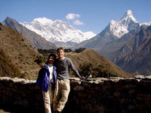 |
Wes and Masami take a relaxing walk above the town of Namche Bazar on their rest day. The mountain to the right is Ama Dablam. A tip of Everest peaks over the range of white on the left. |
|
November 30, Day 16: |
Namche Bazar to Lukla |
SE 3420 meters /
11,220 feet, FE
2840 meters / 9318 feet
ME 3420 meters /
11,220 feet
HW 6.5 hours
+ HR 1 hour
= HT 7.5 hours
After throwing up all night, Masami was in poor shape to walk for 6 hours to Lukla. But considering that the other food poisoned victim staying at the Thamserku View Lodge was in worse condition on days 2 and 3, we decided to try to reach Lukla while Masami was still mobile.
Fernando planned to go to Lukla on the same day and hired a porter the night before. "40 days in the mountains carrying my heavy 35kg pack. But on my last day, I will have a porter and walk free!" he rejoiced. But seeing Masami's condition, Fernando insisted that he carry Masami's pack. We are grateful for his generosity.
Without luggage, Masami managed to stagger to Lukla.
|
December 1, Day 17: |
Lukla to Kathmandu |
December 1 was the day of our original flight reservation to Kathmandu. Masami's food poisoning almost forced a schedule change but we boarded our plane nonetheless. The 09:00 flight left only 2½ hours late at 11:30. Again, fog in Kathmandu was the cause. Once airborne, we saw a noticeable difference in our and the other tourist's behaviors. Flying into Lukla, we stared out the window marveling at the mountains in excited anticipation. Departing from Lukla, we sat back in utter exhaustion uncaring about the scenery. Kathmandu was a short 50 minutes away.
Back in Kathmandu, it was Wes' turn to be food poisoned. We both lay in bed without the energy nor motivation to venture outside.
Absolutely run down with exhaustion, cold, and diarrhea, we need to take a break from trekking and move to a warmer climate. On December 3, we travel south to India.
Assorted Lobuje East expedition summaries:
It's
all pretty.
Copyright © 2000-2002 Wes and Masami Heiser. All rights reserved.