![]()
| Turkey | Doğubeyazıt | 2001.08.19 - 08.24 |
Climbing Mt. Ararat
Mt. Ararat (5137 meters / 16,854 feet) in eastern Turkey on the Iranian border was closed by the Turkish military for 10 years due to "security concerns". This year the mountain is open, provided that climbers obtain a military permit. The Mountain Club (tel: 0472-312-7823, mobile: 0542-516-4649) in Doğubeyazıt (on Belediye Caddesi opposite Hotel Erzurum) has rental gear, applies for military permits for clients, and guides climbers to the summit. Wait time to receive the permit is 3~7 days. For the time being, only Monday departures up the mountain are allowed. Hiking time is 3 to 4 days. There are no facilities on the mountain, and all water must be filtered or boiled.
Mt. Ararat is normally a 4-day hike with 2 altitude acclimatization points. Maps are unavailable and daily hiking distances are long. Finding a knowledgeable mountain guide is essential. We were guided by Mehmet Ertuğrul of the Mountain Club. He's knows the mountain and the local people, but his organization and delegation skills need improvement.
We planned to climb the mountain in 3 days. Masami made it. Wes got sick at camp 2. Either the elevation or water bacteria caused Wes to vomit most of the night. By 02:00, he was in no shape to climb to the summit.
Facts for the Visitor
A military permit (free
but can take up to a week of wait time), and hiking /
snow gear are required to climb Mt. Ararat. Hiring a guide who knows the
mountain is highly recommended. Since this is a militarily controlled area,
hiking and topographical maps are unavailable. All food and 2 days water
supply (at least 6 liters per person) must be carried up.
The critical considerations on the mountain are keeping warm (preventing hypothermia), shielding yourself from sun exposure (UV radiation is 30% stronger every additional 300 meters / 1000 feet of elevation), sufficient water supply (preventing dehydration) and altitude sickness (pulmonary edema and cerebral edema). Do not wear cotton clothing. Cotton absorbs sweat that chills the body. This is the primary cause of hypothermia.
The Climb
Mt. Ararat is a standard 4-day hike, although some people manage to do it
in 3. The below measurements are general guesses since distance and
elevation markers don't exist.
A hired 4-wheel drive dump truck can go 10~15 km up a dirt road from the only paved road heading north from Dogubeyazit. Beyond this point, the road deteriorates too severely for vehicles. Most people start hiking from here.
Day 1 is a 4 hour hike that ascends about 1100 meters from the highest truck stop (approximate elevation 2000 meters / 6562 ft) to camp 1 (approximate elevation 3100 meters / 10,170 ft). The distance is about 8~10km. Camp 1 is a green pasture with stone walls to shield tents from the wind. If horses are hired, they will fetch dirty water from about 3km away. A proper water filter is needed.
Day 2 is a steeper 6 hour hike to camp 2 (approximate elevation 4200 meters / 13,780 ft). The distance is about 10km. Circular clearings among the rocks are tent sites with a natural wind shield. Melted glacier water runs 10 minutes walk up from the camp. Again, a proper water filter is needed.
Day 3 starts at 02:00. The climb from camp 2 to the summit (elevation 5137 meters / 16,854 feet) is 6 hours. Crampons and ice axe are needed for the final hour of ascent. Most people return to camp 2 by 11:00, pack, and descend to camp 1.
Day 4 is a 4 hour descent from camp 1 to the truck stop.
|
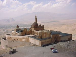
İshakpaşa Palace is 6km from the center of Doğubeyazıt. Completed in 1784, the architecture is a mixture of Seljuk, Ottoman, Georgian, Persian, and Armenian styles. The mosque was used for prayers until 1980. Doors are open from 08:00 ~ 17:30. Admission is TKL 2 million (TKL 1.5 million with student card). |
|
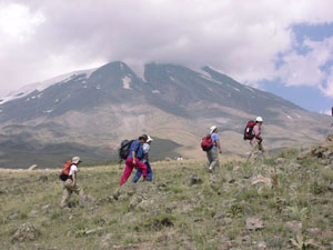
Masami (with orange pack) hikes with a 7 member Japanese group who also contracted with the Mountain Club to climb Mt. Ararat. The Ararat summit is hidden in the clouds. |
|
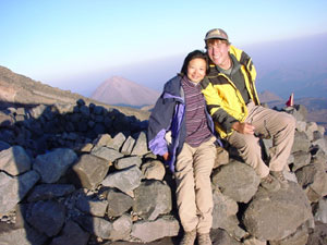
Wes and Masami pose at camp 2 before dinner. The peak of Little Ararat (4100 meters / 13,450 feet) is just to Masami's left in the background. Little Ararat demarks the Turkish-Iranian border. |
|
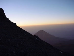
Masami climbs to the Ararat summit on day 3 and photographs the sunrise. Wes stayed at camp 2 hoping to recover. |
|
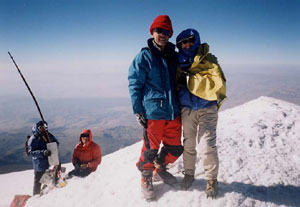
Masami and Doi-san (from Tokyo) pose on the Mt. Ararat summit (5137 meters / 16,854 feet) at 08:00. 2 mountain guides in the background post a plaque in memory of hikers who died climbing in previous years. |
Copyright © 2000-2002 Wes and Masami Heiser. All rights reserved.