![]()
| Italy | Calalzo | 2001.06.23 - 06.29 |
Dolomite Hikes
The Dolomite Mountain Ranges located in northern Italy form a large portion of the eastern Alps. These spiked peaks are ancient coral reefs composed of sedimentary limestone formed from calcium carbonate and magnesium. Marine fossils can be found on these 2000 - 3000 meter high pinnacles. Reaching the peaks requires fitness, strength, and rock climbing gear. We were happy to stick to the standard hiking routes that circle the peaks.
Numerous national parks claim small sections of the Dolomites. We hiked a tiny portion within the boundary of Parco Naturale di Fanes-Sennes-Braies in the eastern part of the Dolomites.
The steepness of the Dolomites makes the hikes challenging. Many routes have sections requiring a harness and rope. These are noted by red
+ marks on detailed 1:25,000 "Tabacco" hiking maps available in towns in and near the Dolomites. We chose a 3-day loop from the town Cortina d'Ampezzo that is listed in the Lonely Planet Italy guidebook. Studying the Tabacco No 03 map, we realized that a route revision was necessary to avoid + marks since we weren't carrying rock climbing gear. Still, we had some difficulty on snow covered elevated sections and washed out steep descents.THREE-DAY HIKE IN PARCO NATURALE FANES-SENNES-BRAIES,
DAY ONE
Our hike started from the top of a cable car station above Passo di
Falzarego, 30km east of Cortina d'Ampezzo. Getting there was much more
expensive than anticipated. A bus connects Calalzo to Cortina (ITL 4500)
year round, but the bus from Cortina to Passo di Falzarego doesn't start
running until July 1. A taxi ride costs ITL 60,000. Sure wish the Lonely
Planet mentioned this late bus start date.
From the top of the cable car (ITL 14,000 up only or ITL 18,000 round trip), the view was more gorgeous than we expected. Spikes of sedimentary stone surrounded us in every direction. We were happy, and we hadn't started to hike yet. The first 3km of our trail was snow covered. Although trail markers were buried, we found our way by judging foot prints in the snow and mountain ridges against the trail marked on our topological map. Progress was slow but we had no trouble with direction. Ascending over a saddle called Forcela Granda at 2770 meters, the view over the Dolomite valley was picture perfect. Descending the saddle on the opposite side, however, we faced difficulty. A steep snow covered slope dropped us a hundred meters to the top of a cliff. Trail markers were buried and foot prints disappeared. We were sure we had lost the trail. 2 Italian hikers found themselves in the same predicament. Between the 4 of us, we inched to the side of the cliff in different locations looking for a possible descent. Every direction seemed to be a sheer 300 meter drop. After 30 minutes of scouting, the Italians turned back muttering, "Impossible." Knowing that we'd never make it to our first refuge reservation if we returned 3 hours back to the cable car, Wes explored one last time. An old washed out trail was found. The descent was unreasonably steep for a hiking path, but we managed to inch our way down through scree, rock, and fragments of lumber and metal that at one time must have been trail supports. Depending on your comfort with rock slides, the descent was exhilarating or scary.
Back on the trail, we assessed our progress. 4 hours of snow trudging, cliff searching, and scree sliding brought us only one-third of the distance to the refuge. The next section of the map was marked in red dots denoting "difficult path with signs, for expert hikers only". Already exhausted, we debated our options. Push forward through the difficult section and see if our energy holds for the remainder, is what we decided. On the way up, a hiker coming from the opposite direction ensured us that beyond this difficult section, the refuge is an easy, relatively flat walk lasting no more than 3 hours. Reassured, we continued onward.
The hiker was telling the truth. Under 3 hours later, we reached Refugio Fanes for our first overnight. Expecting to find a wooden building with makeshift beds and freezing coldwater taps, we were delighted to see that Refugio Fanes is more like a hotel. Our double room was nicely furnished. The comfortable bed had sheets and blankets. Showers were hot. The dinner menu had a large selection. Ahhh. Luxury accommodation after a long, hard hike is the best.
THREE-DAY HIKE IN PARCO NATURALE FANES-SENNES-BRAIES,
DAY TWO
According to our topological map, day two would be an easy 15km with an
option to shorten the distance with a strenuous unmarked 3km trail.
Having learned that "strenuous" in the Dolomites can mean
vertical rock climbing, we decided to budget time
for the 15km walk and decide about the shortcut after seeing it.
5km into the walk, we saw the turnoff for the strenuous trail. The trail seemed to lead directly over a 60° angled scree slope. From there, the trail disappeared over the top. Not today, we decided.
Following the trail that alternated between a dirt road and a hiking trail, we had a pleasant snow-less walk with a lunch stop in a beautiful lush valley by a clear running stream. By early afternoon, we reached Refugio Sennes. Accommodation and dinner here were similar to Refugio Fanes. Sitting on the balcony, we read and updated our journal surrounded by snow capped Dolomite mountains.
THREE-DAY HIKE IN PARCO NATURALE FANES-SENNES-BRAIES,
DAY THREE
The Lonely Planet recommends a lengthy route along trail number 3 that
crosses some mountain ridges marked with
ACCOMMODATION
Cortina d'Ampezzo is conveniently located near several spectacular hikes
in the eastern Dolomites. It's also the town the rich Italian folks use
as their summer retreat. The Lonely Planet warned that budget
accommodation is unavailable. We selected the cheapest Lonely Planet
listing (ITL 180,000 per night!) and were told it's fully booked every
day for the next month. Looking for an alternate base, we stumbled upon
the town of Calalzo, which isn't even listed in the Lonely Planet.
Calling from tourist office to tourist office in the Dolomites, we learned that the train from Venice and other southern points in Italy terminates in the small town of Calalzo, 30km south of Cortina. To reach Cortina, transfer to the Dolomiti Bus in Calalzo, we were told. We phoned the Calalzo tourist information office (tel: 0435 32348) for accommodation information. They provided a list of numbers in our requested "budget" category. From this list we found an excellent B&B run by Lisa Peruz who spent 5 years studying in Tokyo and speaks Japanese and English in addition to Italian, German, and French. Masami was her first Japanese guest, and she was delighted to have us.
TRANSPORTATION IN THE EASTERN DOLOMITES
Public transportation in the Dolomites has a short season. For year
2001, buses run between the following dates:
| Calalzo - Cortina: | year round |
| Cortina eastbound through Passo Falzarego: | July 1 - September 13 |
| Cortina northbound through Cimabanche: | June 23 - September 10 |
| Cortina westbound through Misurina: | July 1 - September 10 |
|
|
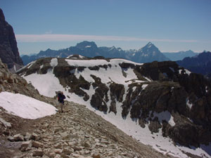
Masami hikes along a rocky trail across Forcella Lagazuoi. |
|
|
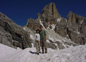
Wes and Masami take a short break near the saddle of Lagazuoi Gran. |
|
|
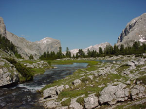
At lower elevation, Val de Fanes is green with small wild flowers and grass. Streams are crystal clear. |
|
|
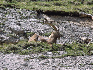
An Ibex watches for threats as his herd leisurely eats from the grassy hillside. |
|
|
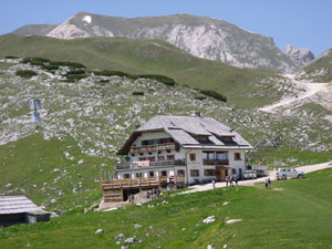
Rifugio Sennes is much different than how we envisioned a mountain hut. The restaurant menu has a wide selection, private rooms are like hotel rooms, and the showers are hot. |
|
|
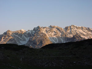
From the Rifugio Sennes balcony, we watched the Dolomite mountains change color as the sun set. |
|
|
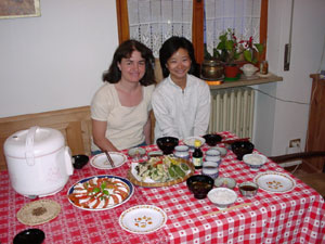
At B&B Quattro Stagioni, we split expenses with Lisa and cooked a delicious dinner of Italian and Japanese food. |
Copyright © 2000-2002 Wes and Masami Heiser. All rights reserved.